Graphic delineations at a set scale, of all or part of the earth or another celestial sphere indicating the relative position of selected artificial and natural features.
File contains a set of presentation drawings on board created by Drew Sperry as his Bachelor of Architecture terminal design project at the Nova Scotia Technical College. Drawings include an urban context map; site plan; mechanical plan, floor plans; elevations; section perspective; and street views.
Collection consists of records with information about individual co-operatives and credit unions in Atlantic Canada, as well as documents from larger region-wide co-operative organizations. There is also a large section of general co-op literature about co-operation as a social movement, in Canada and around the world. There are published books, serials, brochures, reports, photographs and slides, maps, audio and visual material, and artifacts. The age of the materials ranges from the early 1900s up to 2002, the majority spans from the 1950s to the 1990s.
This is a map drawn by the Engineer's Office on September 15, 1913, of the Halifax Harbour - waterfront plan from Bishop Street to Point Pleasant Park and includes proposed changes to the waterfront.
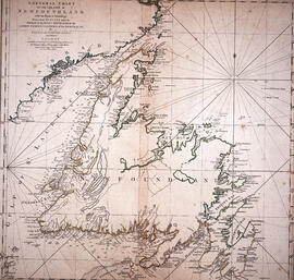
Item is a chart of the Magdalen Islands created by Thomas Jefferys. The chart was published in A Collection of Charts of the coasts of Newfoundland and Labrador (London 1765-1768). Item is entry 604 in Kershaw's Early printed maps of Canada.
File contains hand-drawn and printed maps of coal fields and designated areas, including Pictou coal fields; the Mining Association area; Cape Breton Company's areas; Albion Mines; Stellar Mine; Fraser Oil-Coal Mines; Intercolonial Coal Mining Company property; East River Mining Company area; Acadian Coal Company areas; and the Halifax Company Ltd.
Item is map drawn by H.R. Theakston, University Engineer, showing Dalhousie and other associated buildings on and near both Studley Campus and Carleton Campus. The drawing includes a key indicating the names of both existing and proposed buildings. It was originally made on May 14, 1924 and revised on June 30, 1925.
Item is map drawn by H.R. Theakston, University Engineer, showing Dalhousie and other associated buildings on and near both Studley Campus and Carleton Campus. The drawing includes a key indicating the names of both existing and proposed buildings.
Fonds contains architectural drawings created by Drew Sperry as a student at Nova Scotia Technical College and later as a certified architect. His student work comprises presentation drawings, while the designs for his own home in Dartmouth, Nova Scotia, and two other residential commissions include both presentation and construction drawings. There are two folders of textual records, which comprise a transcript of an interview with Drew and Sheila Sperry, real estate appraisals of their Dartmouth residence, and early budget breakdowns from Sperry's architectural practice.
Collection contains twelve historical maps of Eastern Canada, produced by cartographers such as Giovanni Battista Ramusio and Girolamo Ruscelli. Donation also includes a copy of Kershaw's "Early Printed Maps of Canada" and a "A Monograph of the Evolution of the Boundaries of the Province of New Brunswick" by William F. Ganong.
Series consists of Florence Jessie Murray's correspondence, manuscripts, pamphlets and photographs regarding her involvement in the Korean mission of the United Church of Canada.
Collection contains three historic maps collected by George Burden. The maps depict Cape Breton and Louisbourg, Nova Scotia. Burden acquired the maps from Zwicker's Gallery in Halifax, Nova Scotia.
Item consists of an unattributed hand-drawn, colour map of the Dalhousie University campus, drawn in December 1962, titled "Ground Plan of Dalhousie University".
Subseries consists of Ronald St. John Macdonald's records regarding his involvement with the Gulf of Maine case. Subseries contains correspondence, a memorandum of agreement, newspaper clippings, reports, and other materials.
Item is a hand-coloured engraving of Cape Breton extracted from Atlas minimus, or, A new set of pocket maps of the several empires, kingdoms and states of the known world, published in 1758 by John Gibson and Emmanuel Bowen. The map appeared on page 46 of the book.
File also contains journal entries about the writing tour, written by Budge on the back sides of travel itineraries. The tour was part of the 1987 Children's Book Festival. The file also contains a copy of a map of Saskatchewan and Manitoba with tour destinations marked.
Item is a map of the Africville Area Land Ownership and Buildings, drawn by P.E.J. on July 26, 1962, for the Halifax City Planning Office, at a scale of 1" = 100'. Verso map also contains an inked list of property numbers, some crossed out and others checked off.
Item is a map of British America drawn and engraved by J. Rapkin. Illustrations on the map were drawn by H. Warren and engraved by Robert Wallis. The map was published in J. & F. Tallis' Illustrated atlas, and modern history of the World in 1851.
File consists of a coloured map of Churchill, Manitoba, created by Dwight Allen, for the Polar Inn. Includes two letters between Dany Alard, and Budge Wilson regarding permission to reproduce the map in the book Sharla.
Item is a map of East Canada and New Brunswick drawn and engraved by J. Rapkin. Illustrations on the map were drawn by H. Warren and engraved by Robert Wallis. The map was published in J. & F. Tallis' Illustrated atlas, and modern history of the World in 1851.
Item is a map showing the locations of the mill construction; ruins of the old brick kilns; the clay shed; the new brick kilns; pipe drying; power house and machinery department near the Park Road address.
Item is a map of West Canada drawn and engraved by J. Rapkin. Illustrations on the map were drawn by H. Warren and engraved by Robert Wallis. The map was published in J. & F. Tallis' Illustrated atlas, and modern history of the World in 1851.
Item consists of a plan surveyed by G. G. Grant showing the where the Nova Scotia Power Corporation was to place the transmission line in the Brushy Hill - Lakeside area;
Item consists of the plan of lands at Sackville, Nova Scotia owned by George W. C. Oland as surveyed by R. W. MacKenzie. The property was located between the Lucasville Road, Old Windsor Road, the new Windsor Road and Webber's Lake.
File contains 77 photographs taken by Bill Freedman at Sable Island, Nova Scotia, over several visits between 1981 and 1982. Photographs show vegetation, brackish ponds, aerial surveys, wild horses, as well as some of the researchers. File also includes 3 transparencies.


![Ground plan of Dalhousie University : [map]](/uploads/r/dalhousie-university-archives/0/a/8/0a834f8be003875dbec4cda568fa7e0a24fae39ff5f4cfbb41c3d54d5495bd16/83655f0e-ef17-4831-90a0-73b6ffee38ca-UA-3_487_3_8_142.jpg)


