Plans and maps of the Hawker Siddley - Trenton Works Division plant in Trenton, Nova Scotia
- MS-4-106, OS Box 10, Folder 1
- File
- [ca. 1906]
Part of Trenton Works Ltd. Fonds
This sheets were in an envelope titled - plans, No. 1, Quarter.
157 results directly related Exclude narrower terms
Plans and maps of the Hawker Siddley - Trenton Works Division plant in Trenton, Nova Scotia
Part of Trenton Works Ltd. Fonds

Plan showing properties bounded by Bishop, Hollis, Salter & Water Streets
Part of Oland and Son fonds
Plan showing Lot D1 of the Carl Hamilton property for transfer to Lindwood Farms
Part of Oland and Son fonds

Plan of the city and Harbour of Louisbourg
Part of The Pullen Map Collection
Part of Oland and Son fonds
Plan of survey of lands of Richard H. Oland, Tremont Street, Chester, Lunenburg County, Nova Scotia
Part of Oland and Son fonds
Plan of survey of lands of Lindwood Holdings Limited in Seabright, Halifax County, Nova Scotia
Part of Oland and Son fonds
Plan of survey of Block - WK - Bluenose Wharf, property of A. Keith & Son Limited
Part of Oland and Son fonds
Plan of survey for properties of Olands at Northfield, Hants County, Nova Scotia
Part of Oland and Son fonds

Plan of Studley Estate, site of Dalhousie University
Plan of Maple Cove Sub-division of property of R.A. Logan
Part of Robert A. Logan fonds

Plan du port de Chibouctou à la côte de l'Acadie avec les côtes voisines
Part of The Pullen Map Collection

Part of The Pullen Map Collection
Bellin, Jacques Nicolas, 1703-1772
Photographs of the flora, fauna, and buildings on Sable Island, Nova Scotia
Part of Bill Freedman fonds
Photographs of eight maps included in Ph.D. thesis
Part of James H. Morrison fonds
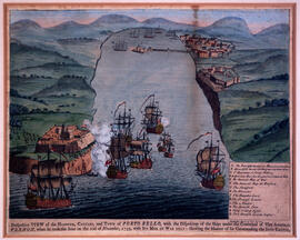
Perspective view of the harbour, coasts and town of Porto Bello
Part of The Pullen Map Collection
Oland Estate : Plan of lands at Sackville, Nova Scotia, property of George W. C. Oland
Part of Oland and Son fonds
Part of Oland and Son fonds
New map of Nova Scotia and Cape Breton Island
Part of The Pullen Map Collection
Material related to the construction of Bruce Oland's property on the Northwest Arm : The Anchor
Part of Oland family fonds
Maps related to the Jos Plateau
Part of James H. Morrison fonds
Maps related to the Gulf of Maine case
Part of Ronald St. John Macdonald fonds
Maps of Lindbergh's flight across the Atlantic (signed by Charles Lindbergh, 1927)
Part of Robert A. Logan fonds
Maps of Korea and Cheju Island
Part of Florence Jessie Murray fonds
Maps of fish farming in the Faroes for 1984, 1990, 1995 and 1999
Part of Richard Apostle fonds
Part of Budge Wilson fonds
Maps for the properties in Lake Charlotte and Ship Harbour related to Robert Logan
Part of Robert A. Logan fonds
Part of The Pullen Map Collection
Part of Standard Clay Products Limited
Map of the lots on Atlantic-Acadia-Brussels streets belonging to J.E. Roy, 1911
Part of Hector McInnes fonds

Map of Petpeswick Harbour Mutual Telephone Company's telephone line
Map of Nova Scotia or Acadia with the islands of Cape Breton and Saint John
Part of The Pullen Map Collection

Map of Musquodoboit Harbour Rural Telephone Company lines
Map of Halifax Harbour outlining an area for possible development
Part of Oland and Son fonds
Map of East Canada and New Brunswick
Part of The Pullen Map Collection
Map of Churchill, Manitoba, created by Dwight Allen
Part of Budge Wilson fonds
Part of George Burden map collection
Randle, Charles, 1755-1813

Map of Brule Mutual Telephone Company's telephone line

Map of Broughton Mutual Telephone Company's telephone line
Part of The Pullen Map Collection

Map of Beaver Bank Rural Telephone Company's telephone line

Mammals of Nova Scotia: with special reference to the five counties district / by Alexander Leighton
Part of Oland and Son fonds
Part of Oland and Son fonds
Part of Oland and Son fonds