File consists of a coloured map of Churchill, Manitoba, created by Dwight Allen, for the Polar Inn. Includes two letters between Dany Alard, and Budge Wilson regarding permission to reproduce the map in the book Sharla.
Collection contains twelve historical maps of Eastern Canada, produced by cartographers such as Giovanni Battista Ramusio and Girolamo Ruscelli. Donation also includes a copy of Kershaw's "Early Printed Maps of Canada" and a "A Monograph of the Evolution of the Boundaries of the Province of New Brunswick" by William F. Ganong.
File also contains journal entries about the writing tour, written by Budge on the back sides of travel itineraries. The tour was part of the 1987 Children's Book Festival. The file also contains a copy of a map of Saskatchewan and Manitoba with tour destinations marked.
File consists of the plans showing the properties that border Lindwood Farms in Sackville, Nova Scotia. These borders include properties owned by Moirs; Hefler Lumber; Wambolt; Hopkins; Hilchie; Davis; Kelsie and Lively.
This is a map drawn by the Engineer's Office on September 15, 1913, of the Halifax Harbour - waterfront plan from Bishop Street to Point Pleasant Park and includes proposed changes to the waterfront.
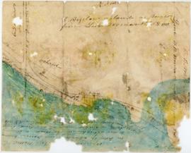
Item consists of an unattributed hand-drawn, colour map of the Dalhousie University campus, drawn in December 1962, titled "Ground Plan of Dalhousie University".
File contains 77 photographs taken by Bill Freedman at Sable Island, Nova Scotia, over several visits between 1981 and 1982. Photographs show vegetation, brackish ponds, aerial surveys, wild horses, as well as some of the researchers. File also includes 3 transparencies.
Subseries consists of Ronald St. John Macdonald's records regarding his consultation work for the Republic of Cyprus. Subseries contains a draft constitution for the Federal Republic of Cyprus, bulletins, newspaper clippings, reports, and other materials.
Item is a drawing of the proposed location of the former archives building (now the Chase Building) on Dalhousie University's Studley campus, showing ground elevations.
Item is a hand-coloured engraving of Cape Breton extracted from Atlas minimus, or, A new set of pocket maps of the several empires, kingdoms and states of the known world, published in 1758 by John Gibson and Emmanuel Bowen. The map appeared on page 46 of the book.
Item is a map of West Canada drawn and engraved by J. Rapkin. Illustrations on the map were drawn by H. Warren and engraved by Robert Wallis. The map was published in J. & F. Tallis' Illustrated atlas, and modern history of the World in 1851.
Item is a map of East Canada and New Brunswick drawn and engraved by J. Rapkin. Illustrations on the map were drawn by H. Warren and engraved by Robert Wallis. The map was published in J. & F. Tallis' Illustrated atlas, and modern history of the World in 1851.
Item is a drawing showing the properties bordered by Bishop Street, Hollis Street, Salter Street, and Water Street in Halifax, Nova Scotia. The drawing shows all of the buildings that are located in this area, including the A. Keith & Son Ltd. building.
Item consists of a survey plan of the property owned by S. C. Oland on the corner of Pleasant Street and Central Street in Chester, Lunenburg County, Nova Scotia as surveyed by Errol Hebb.
File consists of a survey plans of the property known as Block - WK - Bluenose Wharf owned by A. Keith & Son Limited as surveyed by Roy. A. Dunbrack and the Canadian Plant and Process Engineering Limited (CPPE) plan.
Item consists of the plan of lands at Sackville, Nova Scotia owned by George W. C. Oland as surveyed by R. W. MacKenzie. The property was located between the Lucasville Road, Old Windsor Road, the new Windsor Road and Webber's Lake.
File consists of the plan of survey for the property owned by Lindwood Holdings Limited on Young Avenue, Ivanhoe Street and Atlantic Street as surveyed by Wallace MacDonald Surveys Limited.
Item consists of a hand-drawn, colour map of proposed changes to zoning of the Dalhousie University campus, dated December 2, 1965 and drawn by J. Edmonds. Includes proposals of rezoning several blocks from R-3 zone to Park and Institutional zone.
Series consists of Florence Jessie Murray's correspondence, manuscripts, pamphlets and photographs regarding her involvement in the Korean mission of the United Church of Canada.
Item is map drawn by H.R. Theakston, University Engineer, showing Dalhousie and other associated buildings on and near both Studley Campus and Carleton Campus. The drawing includes a key indicating the names of both existing and proposed buildings. It was originally made on May 14, 1924 and revised on June 30, 1925.
File contains hand-drawn and printed maps of coal fields and designated areas, including Pictou coal fields; the Mining Association area; Cape Breton Company's areas; Albion Mines; Stellar Mine; Fraser Oil-Coal Mines; Intercolonial Coal Mining Company property; East River Mining Company area; Acadian Coal Company areas; and the Halifax Company Ltd.
Item is a chart of the Magdalen Islands created by Thomas Jefferys. The chart was published in A Collection of Charts of the coasts of Newfoundland and Labrador (London 1765-1768). Item is entry 604 in Kershaw's Early printed maps of Canada.
Item is a map of British America drawn and engraved by J. Rapkin. Illustrations on the map were drawn by H. Warren and engraved by Robert Wallis. The map was published in J. & F. Tallis' Illustrated atlas, and modern history of the World in 1851.
![Ground plan of Dalhousie University : [map]](/uploads/r/dalhousie-university-archives/0/a/8/0a834f8be003875dbec4cda568fa7e0a24fae39ff5f4cfbb41c3d54d5495bd16/83655f0e-ef17-4831-90a0-73b6ffee38ca-UA-3_487_3_8_142.jpg)


![Proposed rezoning of lands as requested by Dalhousie College and University : [map]](/uploads/r/dalhousie-university-archives/8/6/1/861e617d5c96adf38c584d108c62d54870ae9f68c9c916a83c380a66ad409665/55aba0d1-efab-43d7-bbbd-aef7f5557f2a-UA-3_487_3_9_142.jpg)


