File also contains journal entries about the writing tour, written by Budge on the back sides of travel itineraries. The tour was part of the 1987 Children's Book Festival. The file also contains a copy of a map of Saskatchewan and Manitoba with tour destinations marked.
File consists of a coloured map of Churchill, Manitoba, created by Dwight Allen, for the Polar Inn. Includes two letters between Dany Alard, and Budge Wilson regarding permission to reproduce the map in the book Sharla.
Series consists of research, manuscripts, and drafts of books and short story anthologies written by Budge Wilson. Series also contains some draft illustrations by Budge Wilson and artists with whom she collaborated, including Terry Roscoe, and signed, published copies of her books.
Collection contains twelve historical maps of Eastern Canada, produced by cartographers such as Giovanni Battista Ramusio and Girolamo Ruscelli. Donation also includes a copy of Kershaw's "Early Printed Maps of Canada" and a "A Monograph of the Evolution of the Boundaries of the Province of New Brunswick" by William F. Ganong.
Item is a hand-coloured engraving of Cape Breton extracted from Atlas minimus, or, A new set of pocket maps of the several empires, kingdoms and states of the known world, published in 1758 by John Gibson and Emmanuel Bowen. The map appeared on page 46 of the book.
Item is a drawing of the proposed location of the former archives building (now the Chase Building) on Dalhousie University's Studley campus, showing ground elevations.
File contains social and historical research notes and population medical survey results for the village of Adekanbi. File includes one hand-drawn map.
Subseries consists of Ronald St. John Macdonald's records regarding his consultation work for the Republic of Cyprus. Subseries contains a draft constitution for the Federal Republic of Cyprus, bulletins, newspaper clippings, reports, and other materials.
File contains social and historical research notes and population medical survey results for the village of Agada. File includes three hand-drawn maps of the village. Researchers considered the village traditional.
File contains social and historical research notes and population medical survey results for the village of Ilewo. File includes one hand-drawn map of the village. Researchers considered the village traditional.
File contains social and historical research notes and population medical survey results for the village of Ashipa. File includes three hand-drawn maps of the village. Researchers considered the village modern.
File contains social and historical research notes and population medical survey results for the village of Shodeke. File includes two hand-drawn maps of the village. Researchers considered the village modern.
File contains social and historical research notes, field notes, and population medical survey results for the village of Opeji. File includes four hand-drawn maps of the village.
This is a map drawn by the Engineer's Office on September 15, 1913, of the Halifax Harbour - waterfront plan from Bishop Street to Point Pleasant Park and includes proposed changes to the waterfront.
File contains 77 photographs taken by Bill Freedman at Sable Island, Nova Scotia, over several visits between 1981 and 1982. Photographs show vegetation, brackish ponds, aerial surveys, wild horses, as well as some of the researchers. File also includes 3 transparencies.
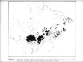
File contains 31 transparencies created and used as teaching aids by Bill Freedman during the 1990s. Transparencies show maps of Canada and Nova Scotia, as well as charts of data, and are drawn largely from the National Atlas of Canada.
Item consists of an unattributed hand-drawn, colour map of the Dalhousie University campus, drawn in December 1962, titled "Ground Plan of Dalhousie University".
Item is a map of West Canada drawn and engraved by J. Rapkin. Illustrations on the map were drawn by H. Warren and engraved by Robert Wallis. The map was published in J. & F. Tallis' Illustrated atlas, and modern history of the World in 1851.
Item is a map of East Canada and New Brunswick drawn and engraved by J. Rapkin. Illustrations on the map were drawn by H. Warren and engraved by Robert Wallis. The map was published in J. & F. Tallis' Illustrated atlas, and modern history of the World in 1851.
Subseries contains files of information for each village in the study. Includes social and historical research notes and population medical survey results. Also contains hand-drawn maps and lists of respondents' names.
File contains social and historical research notes and population medical survey results for the village of Joko. File includes two hand-drawn maps of the village. Researchers considered the village traditional.
Item is a drawing showing the properties bordered by Bishop Street, Hollis Street, Salter Street, and Water Street in Halifax, Nova Scotia. The drawing shows all of the buildings that are located in this area, including the A. Keith & Son Ltd. building.

![Ground plan of Dalhousie University : [map]](/uploads/r/dalhousie-university-archives/0/a/8/0a834f8be003875dbec4cda568fa7e0a24fae39ff5f4cfbb41c3d54d5495bd16/83655f0e-ef17-4831-90a0-73b6ffee38ca-UA-3_487_3_8_142.jpg)