Series comprises Ronald St. John Macdonald's records regarding his professional activities, including his involvement with different organizations, such as the Council of Europe, the European Court of Human Rights, the Hague, World Academy of Arts and Science, Canadian Council of International Law, United Nations, Institute of International Law, African Society of International Law, British Institute of International Law, Canadian Institute of International Law, International Law Association, and others. Series contains meeting agendas, meeting minutes, newsletters, reports, and other records.
File is comprised of documents related to data sampling in the city of Abeokuta. Contains lists of names, notes on divisions of neighbourhoods, and information and statistics relating to city areas and squares. Also contains a large folded map of Abeokuta.
File contains social and historical research notes and population medical survey results for the village of Apena. File includes two hand-drawn maps of the village. Researchers considered the village traditional.
File contains social and historical research notes and population medical survey results for the village of Ikereku. File includes three hand-drawn maps of the village. Researchers considered the village modern.
File contains social and historical research notes and population medical survey results for the village of Ijeun-Lukosi. File includes two hand-drawn maps of the village. Researchers considered the village modern.
File contains social and historical research notes and population medical survey results for the village of Akaa. File includes three hand-drawn maps of the village. Researchers considered the village traditional.
File contains social and historical research notes and population medical survey results for the village of Kutaw. File includes two hand-drawn maps of the village. Researchers considered the village modern.
File contains social and historical research notes and population medical survey results for the village of Ijeja Kenta. File includes two hand-drawn maps of the village. Researchers considered the village traditional.
Item is a map of the harbour of present-day Halifax, Nova Scotia created in 1779 by Joseph-Bernard de Chabert. The map was commissioned by Antoine de Sartine. Depths shown by soundings.
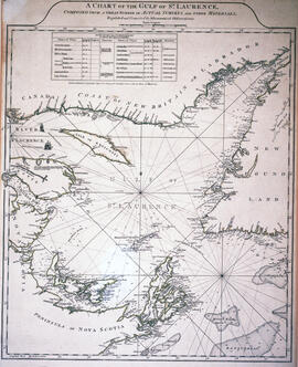
A reproduction of the map "Coast of Acadie" by Lalanne, 1684, reproduced by the Archives du Service Hydrographique de la Marine, Paris in 1933 and used by William Inglis Morse in volume II of Acadiensia Nova in 1935.
File consists of one Municipal Development Plan for Sackville zoning, schedule B; two survey plans surveyed by Wallace MacDonald Limited and one Canadian Plant and Process Engineering Limited (CPPE) plan.
Item consists of the plan of survey for the property owned by Richard H. Oland on Tremont Street in Chester, Nova Scotia and was surveyed by Kyle Harrington.
Item consists of a plan surveyed by G. G. Grant showing the where the Nova Scotia Power Corporation was to place the transmission line in the Brushy Hill - Lakeside area;
Fonds comprises Ronald St. John Macdonald's records regarding his personal, academic, and professional activities as a jurist, judge, and professor. Records include those related to Macdonald's involvement with Osgoode Hall, University of Western Ontario, University of Toronto, Dalhousie University, the European Court of Human Rights, the Hague, Peking University, World Academy of Arts and Science, Canadian Council of International Law, United Nations, Institute of International Law, African Society of International Law, British Institute of International Law, Canadian Institute of International Law, International Law Association, and others. Records types include correspondence; meeting minutes and agendas; research materials; photographs; newsletters; newspaper clippings; manuscripts; and off-prints.
Item is a map of the Africville Area Land Ownership and Buildings, drawn by P.E.J. on July 26, 1962, for the Halifax City Planning Office, at a scale of 1" = 100'. Verso map also contains an inked list of property numbers, some crossed out and others checked off.
Series contains Jill Grant's records from the Joint Review Panel for the Whites Point Quarry and Marine Terminal Project. Materials include the project's environmental impact statement, transcripts from scoping meetings and public hearings, records of the Joint Review Panel, reference and research materials, correspondence, maps and photographs, and other records. The series provides a comprehensive record of the activities of the Joint Review Panel, which was made up by Jill Grant, Robert Fournier and Gunter Muecke.
Subseries consists of Ronald St. John Macdonald's records regarding his involvement with the Gulf of Maine case. Subseries contains correspondence, a memorandum of agreement, newspaper clippings, reports, and other materials.
File contains social and historical research notes and population medical survey results for the village of Ilewo. File includes two hand-drawn maps of the village. Researchers considered the village modern.
File contains social and historical research notes and population medical survey results for the village of Awaro. File includes two hand-drawn maps of the village. Researchers considered the village modern.
File contains social and historical research notes and population medical survey results for the village of Idi-Ori. File includes two hand-drawn maps of the village.
File contains social and historical research notes and population medical survey results for several villages. File includes two hand-drawn maps and several lists of names.
Fonds consists of materials collected by Ronald Justin Inness about ships and shipping companies, including pamphlets, manuscripts, clippings, and correspondence. Fonds also contains manuscripts written by Ronald Justin Inness about the Innes' genealogy.
Item is map drawn by H.R. Theakston, University Engineer, showing Dalhousie and other associated buildings on and near both Studley Campus and Carleton Campus. The drawing includes a key indicating the names of both existing and proposed buildings.
File contains proposed building site plans for Studley Campus drawn by H.R. Theakston, university engineer, as well as topographical maps of the Studley Estate prior to Dalhousie construction, including one created by engineering students. There are also several maps dating between 1922-1928 showing the campus's development.