First and second in series of property lot maps for Atlantic-Brussels-Acadia-Inglis streets
- MS-2-446, OS Folder 1
- File
- [19--]
Part of Hector McInnes fonds
33 results with digital objects Show results with digital objects
First and second in series of property lot maps for Atlantic-Brussels-Acadia-Inglis streets
Part of Hector McInnes fonds
Inness, Ronald Justin
Books and short story anthologies by Budge Wilson
Part of Budge Wilson fonds
Part of Budge Wilson fonds
Plan of survey of lands of Richard H. Oland, Tremont Street, Chester, Lunenburg County, Nova Scotia
Part of Oland and Son fonds
Records from the Joint Review Panel for the Whites Point Quarry and Marine Terminal Project
Part of Jill Grant fonds
Before Green Gables : research notes on Bible Hill and Onslow
Part of Budge Wilson fonds
Before Green Gables : research notes
Part of Budge Wilson fonds
Before Green Gables : research notes for Truro and area
Part of Budge Wilson fonds
Research maps for Before Green Gables
Part of Budge Wilson fonds
Ronald St. John Macdonald fonds
Macdonald, Ronald St. John, 1928-2006
Ronald St. John Macdonald’s professional records
Part of Ronald St. John Macdonald fonds
Sperry, Henry Drew
Atlantic Canada co-operatives collection
Part of Ronald St. John Macdonald fonds
Maps of fish farming in the Faroes for 1984, 1990, 1995 and 1999
Part of Richard Apostle fonds
Edward J. Mullaly Map Collection
Mullaly, Edward J.
Map of Churchill, Manitoba, created by Dwight Allen
Part of Budge Wilson fonds
Part of Oland and Son fonds
Transparencies of Canadian maps used as teaching aids
Part of Bill Freedman fonds
Hand-drawn map of Granville Street, Port Hawkesbury
Part of Christopher Heide fonds
Part of Oland and Son fonds
Itinerary for Wilson's Children's Tour of Saskatchewan
Part of Budge Wilson fonds
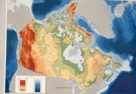
Transparency relief map of Canada
Part of Bill Freedman fonds
Correspondence between Fred and Eloise Jarrett and Henry Davies Hicks
Part of Henry Davies Hicks fonds
Part of Oland and Son fonds
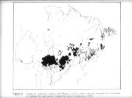
Transparency map showing areas of spruce budworm infestation in eastern Canada, 1981
Part of Bill Freedman fonds
Florence Jessie Murray's records
Part of Florence Jessie Murray fonds
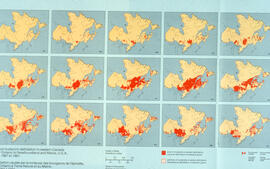
Collage of maps showing the spread of spruce budworm in eastern Canada, 1967-1981
Part of Bill Freedman fonds
Photographs of the flora, fauna, and buildings on Sable Island, Nova Scotia
Part of Bill Freedman fonds

Transparency map of continental shelf off Nova Scotia and Sable Island
Part of Bill Freedman fonds
Plan of survey of lands of Lindwood Holdings Limited in Seabright, Halifax County, Nova Scotia
Part of Oland and Son fonds
Part of Ronald St. John Macdonald fonds

Transparency relief map of Sable Island
Part of Bill Freedman fonds
Part of Oland and Son fonds

Transparency relief map of Sable Island
Part of Bill Freedman fonds
Plan of survey of Block - WK - Bluenose Wharf, property of A. Keith & Son Limited
Part of Oland and Son fonds
Part of Oland and Son fonds
Maps related to the Gulf of Maine case
Part of Ronald St. John Macdonald fonds
Part of Ronald Justin Inness fonds
Dalhousie University campus maps
Part of Dalhousie University Class of 1931 - century package collection
Research materials regarding the revision of the Republic of Cyprus constitution
Part of Ronald St. John Macdonald fonds
Material related to the construction of Bruce Oland's property on the Northwest Arm : The Anchor
Part of Oland family fonds
Photographs of eight maps included in Ph.D. thesis
Part of James H. Morrison fonds
Part of James H. Morrison fonds
Series contains textual records, photographs and maps related to James Morrison's thesis. James Morrison's graduate thesis "Jos Plateau Societies: Internal Change and External Influences, 1800-1935", a thesis in the Department of History, submitted to the Faculty of Arts in partial fulfilment of the requirements for the degree of Doctor of Philosophy of the University of Ibadan. The records relating to James Morrison's thesis span 1973-1976.
Series consists of three subseries: Catalogue cards, Research notes related to the Jos Plateau, and Maps related to the Jos Plateau.
Records relating to the Baileys Brook Mutual Telephone Company Ltd.
Plans showing the property borders surrounding Lindwood Farms, Sackville, Nova Scotia
Part of Oland and Son fonds
Chronological timeline related to Indigenous groups on the Jos Plateau
Part of James H. Morrison fonds
Records relating to the Admiral Rock Mutal Telephone Company Ltd. (Shubenacadia)
Secondary sources related to Birom, Bauchi, Amo, Buji, Jerewa, and Rukuba
Part of James H. Morrison fonds