
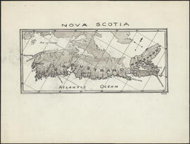
Karte von dem Ostlichen-Stucke von Neu Frankreich oder Canada
- MS-2-756, OS Folder 3
- Item
- 1744
Part of The Pullen Map Collection
Bellin, Jacques Nicolas, 1703-1772
33 results with digital objects Show results with digital objects
Karte von dem Ostlichen-Stucke von Neu Frankreich oder Canada
Part of The Pullen Map Collection
Bellin, Jacques Nicolas, 1703-1772

Plan of the city and Harbour of Louisbourg
Part of The Pullen Map Collection
Part of George Burden map collection
Bowen, Emmanuel, 1694-1767
Port de Louisebourg dans l'Isle Royale
Part of George Burden map collection
Bellin, Jacques Nicolas, 1703-1772

Part of The Pullen Map Collection
Bellin, Jacques Nicolas, 1703-1772
Map of Nova Scotia or Acadia with the islands of Cape Breton and Saint John
Part of The Pullen Map Collection
New map of Nova Scotia and Cape Breton Island
Part of The Pullen Map Collection
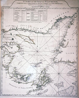
Chart of the Gulf of Saint Lawrence
Part of The Pullen Map Collection
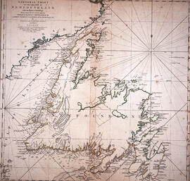
Chart of the Island of Newfoundland
Part of The Pullen Map Collection

Chart of the harbour of Halifax in Nova Scotia
Part of The Pullen Map Collection
Exact chart of the River Saint Lawrence
Part of The Pullen Map Collection

Plan du port de Chibouctou à la côte de l'Acadie avec les côtes voisines
Part of The Pullen Map Collection
Part of George Burden map collection
Randle, Charles, 1755-1813

Chart of the Magdalen Islands in the Gulf of St. Lawrence, surveyed in 1765
Part of The Pullen Map Collection
David and Marilyn Janigan Map Collection
Janigan, David
Part of Bigelow family fonds
Part of The Pullen Map Collection
Map of East Canada and New Brunswick
Part of The Pullen Map Collection
Part of The Pullen Map Collection
Pullen, H.F. (Hugh Francis), 1905-1983
Part of John and Robert Rutherford fonds

Plan of Studley Estate, site of Dalhousie University
Plans and maps of the Hawker Siddley - Trenton Works Division plant in Trenton, Nova Scotia
Part of Trenton Works Ltd. Fonds
Campus map of the Nova Scotia Technical College
Map of the lots on Atlantic-Acadia-Brussels streets belonging to J.E. Roy, 1911
Part of Hector McInnes fonds
Part of Oland and Son fonds
Records relating to the Alma Mutual Telephone Company Ltd.
Research material related to World War I
Part of Archibald MacMechan fonds
Part of R. Graham Murray fonds
Records relating to the Afton & Merlin Mutual Telephone Company Ltd.
Records relating to the Antigonsh & Sherbrooke Mutual Telephone Company Ltd.
Potential medical school site plans and and aerial perspective drawings
Part of Facilities Management
Records relating to the Balls Creek Mutual Telephone Company Ltd.

Dalhousie University grounds and buildings : erected and proposed
Part of Facilities Management
Maps of Lindbergh's flight across the Atlantic (signed by Charles Lindbergh, 1927)
Part of Robert A. Logan fonds

Dalhousie University grounds and buildings : erected and proposed
Part of Facilities Management
Site plans and maps of Studley campus
Part of Facilities Management

Proposed location for the Archives building on Studley campus
Part of Facilities Management
Part of Standard Clay Products Limited

Map of Beaver Bank Rural Telephone Company's telephone line
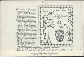
Illustration on page 29 of the first edition of the Markland Sagas : Map of Sigurd Stefansson
Part of Thomas Head Raddall fonds
Part of Thomas Head Raddall fonds
Mammals of Nova Scotia: with special reference to the five counties district / by Alexander Leighton
Oland Estate : Plan of lands at Sackville, Nova Scotia, property of George W. C. Oland
Part of Oland and Son fonds

Map of Brule Mutual Telephone Company's telephone line

Map of Petpeswick Harbour Mutual Telephone Company's telephone line

Map of Broughton Mutual Telephone Company's telephone line

Plan showing properties bounded by Bishop, Hollis, Salter & Water Streets
Part of Oland and Son fonds