Item is a presentation drawing created by Drew Sperry of the urban context of a proposed YMCA for Halifax, which was Sperry's terminal design project for his Bachelor of Architecture degree at the Nova Scotia Technical College. His plan for the recreational complex is superimposed on to a map of Halifax.
File contains proposed building site plans for Studley Campus drawn by H.R. Theakston, university engineer, as well as topographical maps of the Studley Estate prior to Dalhousie construction, including one created by engineering students. There are also several maps dating between 1922-1928 showing the campus's development.
Series comprises Ronald St. John Macdonald's records regarding his professional activities, including his involvement with different organizations, such as the Council of Europe, the European Court of Human Rights, the Hague, World Academy of Arts and Science, Canadian Council of International Law, United Nations, Institute of International Law, African Society of International Law, British Institute of International Law, Canadian Institute of International Law, International Law Association, and others. Series contains meeting agendas, meeting minutes, newsletters, reports, and other records.
Fonds comprises Ronald St. John Macdonald's records regarding his personal, academic, and professional activities as a jurist, judge, and professor. Records include those related to Macdonald's involvement with Osgoode Hall, University of Western Ontario, University of Toronto, Dalhousie University, the European Court of Human Rights, the Hague, Peking University, World Academy of Arts and Science, Canadian Council of International Law, United Nations, Institute of International Law, African Society of International Law, British Institute of International Law, Canadian Institute of International Law, International Law Association, and others. Records types include correspondence; meeting minutes and agendas; research materials; photographs; newsletters; newspaper clippings; manuscripts; and off-prints.
Fonds consists of materials collected by Ronald Justin Inness about ships and shipping companies, including pamphlets, manuscripts, clippings, and correspondence. Fonds also contains manuscripts written by Ronald Justin Inness about the Innes' genealogy.
Subseries consists of Ronald St. John Macdonald's records regarding his consultation work for the Republic of Cyprus. Subseries contains a draft constitution for the Federal Republic of Cyprus, bulletins, newspaper clippings, reports, and other materials.
Series contains Jill Grant's records from the Joint Review Panel for the Whites Point Quarry and Marine Terminal Project. Materials include the project's environmental impact statement, transcripts from scoping meetings and public hearings, records of the Joint Review Panel, reference and research materials, correspondence, maps and photographs, and other records. The series provides a comprehensive record of the activities of the Joint Review Panel, which was made up by Jill Grant, Robert Fournier and Gunter Muecke.
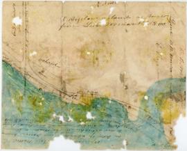
Item consists of a hand-drawn, colour map of proposed changes to zoning of the Dalhousie University campus, dated December 2, 1965 and drawn by J. Edmonds. Includes proposals of rezoning several blocks from R-3 zone to Park and Institutional zone.
Item is a drawing of the proposed location of the former archives building (now the Chase Building) on Dalhousie University's Studley campus, showing ground elevations.
File comprises unrealized aerial perspective and site plan drawings for a future medical school at Dalhousie. There are also two plans of Studley campus showing the potential site for the new King's College buildings.
File consists of the plans showing the properties that border Lindwood Farms in Sackville, Nova Scotia. These borders include properties owned by Moirs; Hefler Lumber; Wambolt; Hopkins; Hilchie; Davis; Kelsie and Lively.
File consists of the plan of survey for the property owned by Lindwood Holdings Limited on Young Avenue, Ivanhoe Street and Atlantic Street as surveyed by Wallace MacDonald Surveys Limited.
File consists of one Municipal Development Plan for Sackville zoning, schedule B; two survey plans surveyed by Wallace MacDonald Limited and one Canadian Plant and Process Engineering Limited (CPPE) plan.
File consists of the plans for the mini hydro power development on the Sackville River, Nova Scotia, McCabe Lake storage dam location drawn by L. E. Powell and Company limited as the engineers and builders.
Item is a drawing showing the properties bordered by Bishop Street, Hollis Street, Salter Street, and Water Street in Halifax, Nova Scotia. The drawing shows all of the buildings that are located in this area, including the A. Keith & Son Ltd. building.
Item consists of a survey plan of the property owned by S. C. Oland on the corner of Pleasant Street and Central Street in Chester, Lunenburg County, Nova Scotia as surveyed by Errol Hebb.
Item consists of the plan of survey for the property owned by Richard H. Oland on Tremont Street in Chester, Nova Scotia and was surveyed by Kyle Harrington.
File consists of two plan surveys of property in Seabright. Plan survey of lands of Lindwood Holdings Limited, Seabright, Lot 15 and was surveyed by Wallace MadDonald and Lively Limited in 1982 and Plan survey of lands of Lindwood Holdings Limited, Seabright, Lot 6A, 7 and 7B, formerly Graham K. Brundige property and was surveyed by Thompson and Purcell Surveying Limited in 1981.
File consists of a survey plans of the property known as Block - WK - Bluenose Wharf owned by A. Keith & Son Limited as surveyed by Roy. A. Dunbrack and the Canadian Plant and Process Engineering Limited (CPPE) plan.
Item is a map of the harbour of present-day Halifax, Nova Scotia created in 1779 by Joseph-Bernard de Chabert. The map was commissioned by Antoine de Sartine. Depths shown by soundings.
File contains 77 photographs taken by Bill Freedman at Sable Island, Nova Scotia, over several visits between 1981 and 1982. Photographs show vegetation, brackish ponds, aerial surveys, wild horses, as well as some of the researchers. File also includes 3 transparencies.


![Proposed rezoning of lands as requested by Dalhousie College and University : [map]](/uploads/r/dalhousie-university-archives/8/6/1/861e617d5c96adf38c584d108c62d54870ae9f68c9c916a83c380a66ad409665/55aba0d1-efab-43d7-bbbd-aef7f5557f2a-UA-3_487_3_9_142.jpg)