Fonds comprises family papers, including an 1821 deed to the Perkins family of Liverpool, an 1824 royal land grant to Enos Collins of Liverpool, an 1845 letter of appointment of Samuel P. Fairbanks, Queen's Council, signed by Queen Victoria, and the last will and testament of Henry Newton.
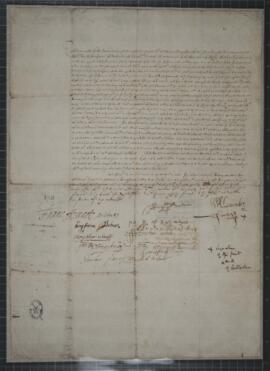
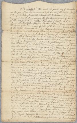
Item is a legal document between Sir John Wentworth and Matthew Richardson. The document involves land originally secured by William Dawes Quarrell for Maroons that the British sent to Nova Scotia from Trelawny Town, Jamaica in 1790s.
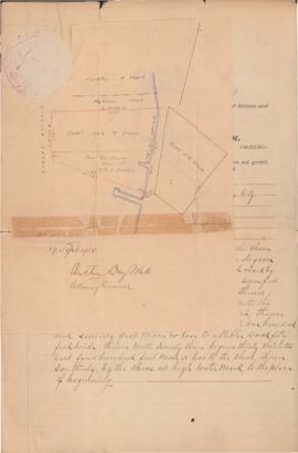
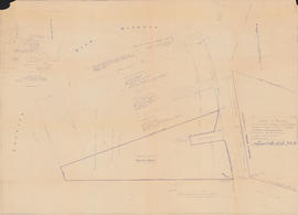
File contains a document from the Province of Nova Scotia granting a lot of land located in the harbour in Chester, Nova Scotia to James M. Allen of Halifax; and a map showing a survey of Provincial Water Grant No. 20618, in the Back Harbour of Chester, Lunenburg, Nova Scotia. See MS-4-135, Box 35, Folder 16 for related documents.
Item is a document from the Province of Nova Scotia granting a lot of land located in the harbour in Chester, Nova Scotia to James M. Allen of Halifax. The land was granted to Allen for fifty dollars on September 25th, 1905 by the order of the Governor-in-Council. There is a small map of the lot attached to the front of the document with a seal.
Item is a map showing a survey of Provincial Water Grant No. 20618, in the Back Harbour of Chester, Lunenburg, Nova Scotia. The surveys were conducted on June 10th and 11th, 1954 by Errol B. Hebb of Bridgewater, Nova Scotia. The map shows the shoreline along Shore Road, including wharves and lots currently or formerly owned by Clarissa Gibbs, James M. Allen, Andrew Anderson, C. Orchiltree MacDonald, E. R. Paxton, Elizabeth Allen, Verginia M. Allen, Mary L. Ritchie, Florence B. McCurdy, and William F. Bryans. There is also a small map of the Chester area inset in the upper left corner of the drawing.