Fonds comprises Ronald St. John Macdonald's records regarding his personal, academic, and professional activities as a jurist, judge, and professor. Records include those related to Macdonald's involvement with Osgoode Hall, University of Western Ontario, University of Toronto, Dalhousie University, the European Court of Human Rights, the Hague, Peking University, World Academy of Arts and Science, Canadian Council of International Law, United Nations, Institute of International Law, African Society of International Law, British Institute of International Law, Canadian Institute of International Law, International Law Association, and others. Records types include correspondence; meeting minutes and agendas; research materials; photographs; newsletters; newspaper clippings; manuscripts; and off-prints.
File also contains journal entries about the writing tour, written by Budge on the back sides of travel itineraries. The tour was part of the 1987 Children's Book Festival. The file also contains a copy of a map of Saskatchewan and Manitoba with tour destinations marked.
File consists of a coloured map of Churchill, Manitoba, created by Dwight Allen, for the Polar Inn. Includes two letters between Dany Alard, and Budge Wilson regarding permission to reproduce the map in the book Sharla.
Item is a map of the harbour of present-day Halifax, Nova Scotia created in 1779 by Joseph-Bernard de Chabert. The map was commissioned by Antoine de Sartine. Depths shown by soundings.
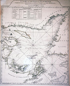
Item is a chart of the Magdalen Islands created by Thomas Jefferys. The chart was published in A Collection of Charts of the coasts of Newfoundland and Labrador (London 1765-1768). Item is entry 604 in Kershaw's Early printed maps of Canada.
Item is a map of British America drawn and engraved by J. Rapkin. Illustrations on the map were drawn by H. Warren and engraved by Robert Wallis. The map was published in J. & F. Tallis' Illustrated atlas, and modern history of the World in 1851.
Item is a map of West Canada drawn and engraved by J. Rapkin. Illustrations on the map were drawn by H. Warren and engraved by Robert Wallis. The map was published in J. & F. Tallis' Illustrated atlas, and modern history of the World in 1851.
Item is a map of East Canada and New Brunswick drawn and engraved by J. Rapkin. Illustrations on the map were drawn by H. Warren and engraved by Robert Wallis. The map was published in J. & F. Tallis' Illustrated atlas, and modern history of the World in 1851.
File contains 77 photographs taken by Bill Freedman at Sable Island, Nova Scotia, over several visits between 1981 and 1982. Photographs show vegetation, brackish ponds, aerial surveys, wild horses, as well as some of the researchers. File also includes 3 transparencies.
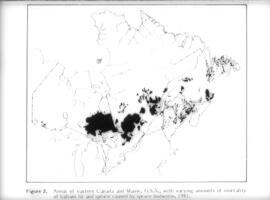
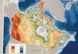
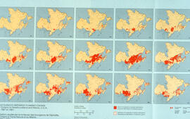
File contains 31 transparencies created and used as teaching aids by Bill Freedman during the 1990s. Transparencies show maps of Canada and Nova Scotia, as well as charts of data, and are drawn largely from the National Atlas of Canada.
Fonds contains architectural drawings created by Drew Sperry as a student at Nova Scotia Technical College and later as a certified architect. His student work comprises presentation drawings, while the designs for his own home in Dartmouth, Nova Scotia, and two other residential commissions include both presentation and construction drawings. There are two folders of textual records, which comprise a transcript of an interview with Drew and Sheila Sperry, real estate appraisals of their Dartmouth residence, and early budget breakdowns from Sperry's architectural practice.
File contains a set of presentation drawings on board created by Drew Sperry as his Bachelor of Architecture terminal design project at the Nova Scotia Technical College. Drawings include an urban context map; site plan; mechanical plan, floor plans; elevations; section perspective; and street views.
Item is a presentation drawing created by Drew Sperry of the urban context of a proposed YMCA for Halifax, which was Sperry's terminal design project for his Bachelor of Architecture degree at the Nova Scotia Technical College. His plan for the recreational complex is superimposed on to a map of Halifax.
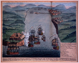
Collection contains three historic maps collected by George Burden. The maps depict Cape Breton and Louisbourg, Nova Scotia. Burden acquired the maps from Zwicker's Gallery in Halifax, Nova Scotia.
Item is a hand-coloured engraving of Cape Breton extracted from Atlas minimus, or, A new set of pocket maps of the several empires, kingdoms and states of the known world, published in 1758 by John Gibson and Emmanuel Bowen. The map appeared on page 46 of the book.
Series contains Jill Grant's records from the Joint Review Panel for the Whites Point Quarry and Marine Terminal Project. Materials include the project's environmental impact statement, transcripts from scoping meetings and public hearings, records of the Joint Review Panel, reference and research materials, correspondence, maps and photographs, and other records. The series provides a comprehensive record of the activities of the Joint Review Panel, which was made up by Jill Grant, Robert Fournier and Gunter Muecke.