- MS-4-135.2019-046, OS Folder 47
- File
- 1962 - 1963
Part of Oland and Son fonds
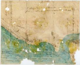
This file consists of a map of the Lindwood Farms and the surrounding area.
23 results with digital objects Show results with digital objects
Part of Oland and Son fonds
Plans showing the property borders surrounding Lindwood Farms, Sackville, Nova Scotia
Part of Oland and Son fonds
Part of Bigelow family fonds
Plan showing Lot D1 of the Carl Hamilton property for transfer to Lindwood Farms
Part of Oland and Son fonds
Part of Oland and Son fonds
![Ground plan of Dalhousie University : [map]](/uploads/r/dalhousie-university-archives/0/a/8/0a834f8be003875dbec4cda568fa7e0a24fae39ff5f4cfbb41c3d54d5495bd16/83655f0e-ef17-4831-90a0-73b6ffee38ca-UA-3_487_3_8_142.jpg)
Ground plan of Dalhousie University : [map]
Part of President’s Office fonds

Map of Beaver Bank Rural Telephone Company's telephone line
Records relating to the Abrierl Fisheries Telephone Company Ltd., Tangier Exchange
Records relating to the Alma Mutual Telephone Company Ltd.
Records relating to the Baileys Brook Mutual Telephone Company Ltd.
Records relating to the Barra Glen Mutual Telephone Company Ltd.
Dalhousie University campus maps
Part of Dalhousie University Class of 1931 - century package collection
Photographs of the flora, fauna, and buildings on Sable Island, Nova Scotia
Part of Bill Freedman fonds
Part of Ronald St. John Macdonald fonds

Proposed location for the Archives building on Studley campus
Part of Facilities Management
Port de Louisebourg dans l'Isle Royale
Part of George Burden map collection
Bellin, Jacques Nicolas, 1703-1772
Part of George Burden map collection
Bowen, Emmanuel, 1694-1767
Maps of Lindbergh's flight across the Atlantic (signed by Charles Lindbergh, 1927)
Part of Robert A. Logan fonds
Before Green Gables : research notes on Bible Hill and Onslow
Part of Budge Wilson fonds

Karte von dem Ostlichen-Stucke von Neu Frankreich oder Canada
Part of The Pullen Map Collection
Bellin, Jacques Nicolas, 1703-1772

Transparency map of continental shelf off Nova Scotia and Sable Island
Part of Bill Freedman fonds
First and second in series of property lot maps for Atlantic-Brussels-Acadia-Inglis streets
Part of Hector McInnes fonds

Plan showing properties bounded by Bishop, Hollis, Salter & Water Streets
Part of Oland and Son fonds
Part of Oland and Son fonds
Plan of survey of Block - WK - Bluenose Wharf, property of A. Keith & Son Limited
Part of Oland and Son fonds
Oland Estate : Plan of lands at Sackville, Nova Scotia, property of George W. C. Oland
Part of Oland and Son fonds
Part of Oland and Son fonds
![Proposed rezoning of lands as requested by Dalhousie College and University : [map]](/uploads/r/dalhousie-university-archives/8/6/1/861e617d5c96adf38c584d108c62d54870ae9f68c9c916a83c380a66ad409665/55aba0d1-efab-43d7-bbbd-aef7f5557f2a-UA-3_487_3_9_142.jpg)
Proposed rezoning of lands as requested by Dalhousie College and University : [map]
Part of President’s Office fonds
Florence Jessie Murray's records
Part of Florence Jessie Murray fonds

Map of Brule Mutual Telephone Company's telephone line

Map of Petpeswick Harbour Mutual Telephone Company's telephone line
Records relating to the Admiral Rock Mutal Telephone Company Ltd. (Shubenacadia)
Records relating to the Afton & Merlin Mutual Telephone Company Ltd.
Records relating to the Athol Rural Telephone Company Ltd.

Dalhousie University grounds and buildings : erected and proposed
Part of Facilities Management
Part of George Burden map collection
Randle, Charles, 1755-1813
Hand-drawn map of Granville Street, Port Hawkesbury
Part of Christopher Heide fonds
Part of John and Robert Rutherford fonds
Maps for the properties in Lake Charlotte and Ship Harbour related to Robert Logan
Part of Robert A. Logan fonds
Before Green Gables : research notes for Truro and area
Part of Budge Wilson fonds
Map of Nova Scotia or Acadia with the islands of Cape Breton and Saint John
Part of The Pullen Map Collection

Plan of the city and Harbour of Louisbourg
Part of The Pullen Map Collection
Part of Oland and Son fonds
Plan of survey of lands of Lindwood Holdings Limited in Seabright, Halifax County, Nova Scotia
Part of Oland and Son fonds
Part of Oland and Son fonds
Campus map of the Nova Scotia Technical College

Transparency relief map of Sable Island
Part of Bill Freedman fonds
Records relating to the Abercrombie Mutal Telephone Company Ltd.
Records relating to the Alder Point Mutual Telephone Company Ltd.
Records relating to the Antigonsh & Sherbrooke Mutual Telephone Company Ltd.