Oland Estate : Plan of lands at Sackville, Nova Scotia, property of George W. C. Oland
Oland Estate : Plan of lands at Sackville, Nova Scotia, property of George W. C. Oland
Nova Scotia Power Corporation plan of lots 16 - 17b, Brushy Hill - Lakeside, placement of the transmission line
Nova Scotia Power Corporation plan of lots 16 - 17b, Brushy Hill - Lakeside, placement of the transmission line
Maps related to the Gulf of Maine case
Maps related to the Gulf of Maine case
Maps of Lindbergh's flight across the Atlantic (signed by Charles Lindbergh, 1927)
Maps of Lindbergh's flight across the Atlantic (signed by Charles Lindbergh, 1927)
Maps for tour of Newfoundland
Maps for tour of Newfoundland
Maps for the properties in Lake Charlotte and Ship Harbour related to Robert Logan
Maps for the properties in Lake Charlotte and Ship Harbour related to Robert Logan
Map of West Canada
Map of West Canada
Map of the Standard Clay Products Ltd, New Glasgow, Nova Scotia and D LeBlanc & Fils Limitee property / by J. Saur
Map of the Standard Clay Products Ltd, New Glasgow, Nova Scotia and D LeBlanc & Fils Limitee property / by J. Saur
Map of the lots on Atlantic-Acadia-Brussels streets belonging to J.E. Roy, 1911
Map of the lots on Atlantic-Acadia-Brussels streets belonging to J.E. Roy, 1911

Map of Petpeswick Harbour Mutual Telephone Company's telephone line
Map of Nova Scotia or Acadia with the islands of Cape Breton and Saint John
Map of Nova Scotia or Acadia with the islands of Cape Breton and Saint John

Map of Musquodoboit Harbour Rural Telephone Company lines
Map of Halifax Harbour outlining an area for possible development
Map of Halifax Harbour outlining an area for possible development
Map of East Canada and New Brunswick
Map of East Canada and New Brunswick
Map of Churchill, Manitoba, created by Dwight Allen
Map of Churchill, Manitoba, created by Dwight Allen
Map of Cape Breton
Map of Cape Breton

Map of Brule Mutual Telephone Company's telephone line

Map of Broughton Mutual Telephone Company's telephone line

Map of Beaver Bank Rural Telephone Company's telephone line

Map of Africville
Lindwood farm property map
Lindwood farm property map
Lindwood farm and vincity near Middle Sackville, Nova Scotia prepared, 1945, from existing air photographs and maps
Lindwood farm and vincity near Middle Sackville, Nova Scotia prepared, 1945, from existing air photographs and maps
Legal documents related to Lindwood Holdings Ltd. and the purchase of the Seabright, Nova Scotia properties
Legal documents related to Lindwood Holdings Ltd. and the purchase of the Seabright, Nova Scotia properties

Karte von dem Ostlichen-Stucke von Neu Frankreich oder Canada
Itinerary for Wilson's Children's Tour of Saskatchewan
Itinerary for Wilson's Children's Tour of Saskatchewan
Island of Cape Breton
Island of Cape Breton
Hand-drawn map of Granville Street, Port Hawkesbury
Hand-drawn map of Granville Street, Port Hawkesbury
Gulf of Maine case
Gulf of Maine case
![Ground plan of Dalhousie University : [map]](/uploads/r/dalhousie-university-archives/0/a/8/0a834f8be003875dbec4cda568fa7e0a24fae39ff5f4cfbb41c3d54d5495bd16/83655f0e-ef17-4831-90a0-73b6ffee38ca-UA-3_487_3_8_142.jpg)
Ground plan of Dalhousie University : [map]
George Burden map collection
George Burden map collection
Florence Jessie Murray's records
Florence Jessie Murray's records
First and second in series of property lot maps for Atlantic-Brussels-Acadia-Inglis streets
First and second in series of property lot maps for Atlantic-Brussels-Acadia-Inglis streets
Exact chart of the River Saint Lawrence
Exact chart of the River Saint Lawrence
Edward J. Mullaly Map Collection
Edward J. Mullaly Map Collection
Drew Sperry fonds
Drew Sperry fonds

Dalhousie University grounds and buildings : erected and proposed

Dalhousie University grounds and buildings : erected and proposed
Dalhousie University campus maps
Dalhousie University campus maps
Colliery and mining maps
Colliery and mining maps

Chart of the Magdalen Islands in the Gulf of St. Lawrence, surveyed in 1765
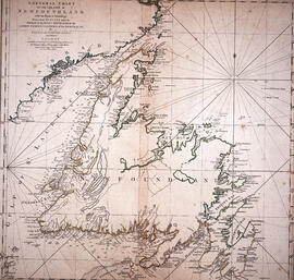
Chart of the Island of Newfoundland

Chart of the harbour of Halifax in Nova Scotia
Canadian government railways Halifax ocean terminals docks (first unit) contract no. 3, general plan (Halifax Harbour-waterfront plan)
Canadian government railways Halifax ocean terminals docks (first unit) contract no. 3, general plan (Halifax Harbour-waterfront plan)
Campus map of the Nova Scotia Technical College
Campus map of the Nova Scotia Technical College
Before Green Gables : research notes on Bible Hill and Onslow
Before Green Gables : research notes on Bible Hill and Onslow
Before Green Gables : research notes for Truro and area
Before Green Gables : research notes for Truro and area
Atlantic Canada co-operatives collection
Atlantic Canada co-operatives collection
A YMCA for Halifax
A YMCA for Halifax