File also contains journal entries about the writing tour, written by Budge on the back sides of travel itineraries. The tour was part of the 1987 Children's Book Festival. The file also contains a copy of a map of Saskatchewan and Manitoba with tour destinations marked.
File contains keepsakes from Alexander Leighton's trip to Japan, including photographs, postcards, maps, medical documents and immunization records, and travel itineraries.
File contains social and historical research notes and population medical survey results for the village of Joko. File includes two hand-drawn maps of the village. Researchers considered the village traditional.
File consists of seven black and white maps of the Jos Plateau. The maps display national boundaries, migration routes, settlements, ethnic groups, pathways of British expeditions and main roads.
File consists of eighteen black and white, and colour maps of the Jos Plateau. The file includes five transparent copies of maps of the Jos Plateau used in James Morrison's thesis. The remaining thirteen maps are a combination of government and topographical maps of the Jos Plateau region of Nigeria.
File contains social and historical research notes and population medical survey results for the village of Kutaw. File includes two hand-drawn maps of the village. Researchers considered the village modern.
Item is a map of the Africville Area Land Ownership and Buildings, drawn by P.E.J. on July 26, 1962, for the Halifax City Planning Office, at a scale of 1" = 100'. Verso map also contains an inked list of property numbers, some crossed out and others checked off.
Item is a map of British America drawn and engraved by J. Rapkin. Illustrations on the map were drawn by H. Warren and engraved by Robert Wallis. The map was published in J. & F. Tallis' Illustrated atlas, and modern history of the World in 1851.
File consists of a coloured map of Churchill, Manitoba, created by Dwight Allen, for the Polar Inn. Includes two letters between Dany Alard, and Budge Wilson regarding permission to reproduce the map in the book Sharla.
Item is a map of East Canada and New Brunswick drawn and engraved by J. Rapkin. Illustrations on the map were drawn by H. Warren and engraved by Robert Wallis. The map was published in J. & F. Tallis' Illustrated atlas, and modern history of the World in 1851.
Item is a map showing the locations of the mill construction; ruins of the old brick kilns; the clay shed; the new brick kilns; pipe drying; power house and machinery department near the Park Road address.
Item is a map of West Canada drawn and engraved by J. Rapkin. Illustrations on the map were drawn by H. Warren and engraved by Robert Wallis. The map was published in J. & F. Tallis' Illustrated atlas, and modern history of the World in 1851.
Subseries consists of twenty five maps related to James Morrison's thesis on the Jos Plateau. Seven of the maps were used in Morrison's published thesis, the others are supporting research documents and are a mix of government produced and hand drawn. The maps depict Nigeria and the Jos Plateau region.
Subseries contains files of information for each village in the study. Includes social and historical research notes and population medical survey results. Also contains hand-drawn maps and lists of respondents' names.
Item consists of a plan surveyed by G. G. Grant showing the where the Nova Scotia Power Corporation was to place the transmission line in the Brushy Hill - Lakeside area;
Item consists of the plan of lands at Sackville, Nova Scotia owned by George W. C. Oland as surveyed by R. W. MacKenzie. The property was located between the Lucasville Road, Old Windsor Road, the new Windsor Road and Webber's Lake.
File contains social and historical research notes and population medical survey results for the village of Ilewo. File includes one hand-drawn map of the village. Researchers considered the village traditional.
File contains social and historical research notes, field notes, and population medical survey results for the village of Opeji. File includes four hand-drawn maps of the village.
File contains 77 photographs taken by Bill Freedman at Sable Island, Nova Scotia, over several visits between 1981 and 1982. Photographs show vegetation, brackish ponds, aerial surveys, wild horses, as well as some of the researchers. File also includes 3 transparencies.
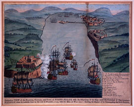
Item is a map of the harbour of present-day Halifax, Nova Scotia created in 1779 by Joseph-Bernard de Chabert. The map was commissioned by Antoine de Sartine. Depths shown by soundings.
File consists of a survey plans of the property known as Block - WK - Bluenose Wharf owned by A. Keith & Son Limited as surveyed by Roy. A. Dunbrack and the Canadian Plant and Process Engineering Limited (CPPE) plan.