Print preview Close

Showing 177 results

Archival Description
Ships With digital objects
Print preview View:

Scrapbook page with photographs of T.H. Raddall, Sr. with a rifle division, and Thomas Head Raddall working aboard ships

Item may have been a page in one of Thomas Head Raddall's photograph albums. Two of the photographs are duplicates from Thomas Head Raddall's photograph album, 1917-1927. The bottom middle and bottom right pictures were taken aboard the S.S. Watuka, while the bottom left may have been taken on the cable-ship Mackay-Bennett.

Photograph of three ships docked at Circular Quay in Sydney, Australia

Item is a photograph of three docked ships: the Dunbar Castle, which weighed 925 tons, and was built in Sunderland, England in 1864; the Borden Chief, which weighed 1011 tons, and was built in South Shields in 1870; and the Duke of Sutherlans, which weighed 1047 tons and was built in Aberdeen in 1865.

Photograph of the German submarine U-889 shortly after its surrender to Canadian naval forces near Shelburne, Nova Scotia

Item, a photograph, is related to material found in Thomas Head Raddall's photograph album [between 1940 and 1959] and to MS-2-202, Box 55, Folder 22, Item 8 in subseries Thomas Head Raddall's loose photographs. The photograph has a stamp marking it copyright to the Royal Canadian Navy on the reverse side.

Photograph of a man looking at a hole in the keel of a salvaged boat, sitting on a beach at Seal Island with a small crowd of people amassed to observe

Item is a photograph of a salvaged boat. The hole in its keel was sustained by striking a piece of steel. An American ship went aground between Seal Island and Blonde Rock during World War II, and steel cargo was thrown overboard in an effort to lighten the vessel for subsequent salvage operations. The ejected steel remains a menace to fishing boats in those waters, where the tide rises and falls with a large margin.

Pencil and ink silhouettes by Donald Cameron Mackay of seven allied ships

Item consists of seven small pencil and ink silhouette ship drawings by D.C. Mackay on India paper in the early 1940s. Ships depicted include RMS Aquitania, RMS Monarch of Bermuda/Queen of Bermuda, RMS Empress of Britain, RMS Empress of Australia, HMS Malaya, HMS Valiant, and HMS Enterprise. Includes tonnage and dimensions information.

Photograph of the "Avon Queen"

Item is a photograph of the Avon Queen taken by Isaac Erb and Son, Saint John. Writing on back states that the ship (939 tons) was built at Hantsport, N.S. in 1918. Also says, "a four-masted schooner at Saint John, N.B." and "as the Jessie Louise Farquier"

Manuscript journal, detailing an expedition along the Atlantic Coast of Nova Scotia and parts of New Brunswick situated on the Bay of Fundy, July 19, 1684 – September 14, 1684

  • MS-2-370, Oversize Folder 1
  • Item
  • July 19, 1684 – September 14, 1684

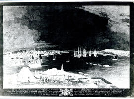
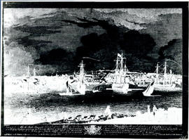
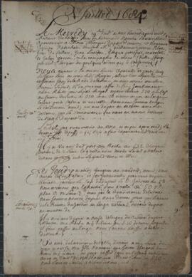
Item is a cartographic journal containing daily entries and twenty-five cartographic diagrams and topographical illustrations showing coastlines, elevations, distances (in leagues), water depths, capes, bays, rivers, inlets, islands and other geographical features.

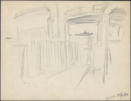
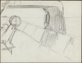
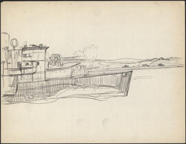
From the accounts of the first few days, the jump off point must have been somewhere near Mahone Bay or Lunenburg, on the southern coast of Nova Scotia. Few observations are recorded during the first week; the aim seems to have been to reach an initial destination of Grand Manan Island. At this point, beginning on July 25, 1684, detailed observations are made of all islands, rocks, and other geographical objects, along with more specific information concerning water depths (given in braces), types of currents, prevailing winds, distances between landmarks (given in leagues), places of secure anchorage, danger zones, etc. Most of the observed areas are accompanied by topographical illustrations which depict not only the contours of the coastline, but also elevations from sea level.

The expedition proceeded from Grand Manan Island down into Passamaquoddy Bay (this is not named, but the St. Croix River is), then Northeast along the coast of New Brunswick to the entrance to the St. John River. At this point, the expedition encountered at least two British war vessels, equipped with cannons. An envoy from the expedition was sent to the British ships, apparently commanded by John Nelson, the nephew of the first proprietor of New Brunswick; assurances are exchanged, the envoy is returned, and the expedition again proceeds along its way. Much of this portion of the expedition was obscured by a dense and persistent thick fog which made the task of the cartographer at times impossible, as he frequently notes.

From St. John River, the expedition turned back again across the Bay of Fundy, along Long Island, down along the Western coast of Nova Scotia to Cape Sable. This destination is reached by July 31, 1684, and here some days are passed waiting out a violent storm. Another British ship is mentioned, though no contact was made. The coastline from Cape Sable all the way to Margaret's Bay is represented by numerous illustrations. The weather seems to have been more favourable, and much of the area was apparently uncharted.

This portion of the journey includes descriptions and illustrations of Cape Negro, Baye du Port Razor, Riv. des Jardins, Port Rosignol, Sable River, La Have Harbour, Mahone Bay (called here Mirligaich), Margaret's Bay, etc. The expedition continues from Margaret's Bay on to the Northeast, with observations of Cape Sambro, Riv. Chibouetou. Riv. Maganchis, Cape Thiodor, and it ends at St. Mary's River, on September 14, 1684.

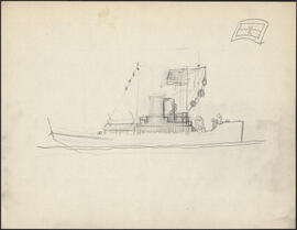
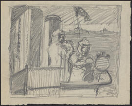
Appended to the journal is a twelve page "Inventaire pour servir a l'armament et consommation du nav(igation)," in which a very detailed list of hundreds of items is presented. The two categories that receive the most attention are boat fixtures (e.g., sails, bowsprites, halyards, stays, topsails, masts, anchors, rope, riggings, etc.) and armaments (e.g., cannons, ammunitions, guns, other weapons, etc.). Surgical equipment is briefly mentioned. Extraneous observations are also included from time to time: an abundance of fish off Cape Forcheau; arborage and foliage on shore; disembarkments, during one of which one of the crew apparently attempted to desert.

Marianne (Ship)

Aerial photograph of the accommodation ship Franklin in Voisey's Bay, Newfoundland and Labrador

Item consists of a photograph of the Franklin, a Canadian Coast Guard vessel which served research needs in the Voisey's Bay area as an accommodation ship between 1996 and 2000. The ship was launched in 1979, but was declared as surplus in 1996. In 2003, the Franklin was recommissioned as the CCGS Amundsen, an arctic research vessel.

Proposed schematic diagram of electrical distribution 230 V.-115 V. A.C. & 115 V. D.C.

Item consists of two copies of proposed schematic diagram of the electrical distribution of the Bluenose II. The drawing is labelled "Sketch No H.S.L.-BL/EL-18." The drawing was completed on January 29th, 1965 for Halifax Shipyards. One copy of the drawing includes a table of estimated sea loads that is not present on the other copy

Suggested exhibit signs : Bluenose II

Item is a list of suggested exhibit signs for the Bluenose II. The list includes signs to place on the wharf, on the deck, and on other places on the ship.

Suggested exhibit signs : Bluenose II

Item is a list of suggested exhibit signs for the Bluenose II. The list includes signs to place on the wharf, on the deck, and on other places on the ship.
Results 1 to 50 of 177