The apple enterprise in the Annapolis Valley of Nova Scotia
- MS-14-13, MS-14, Box 6, Folder 8, Item 3
- Item
- 1958
Part of George C Retson fonds
65 results with digital objects Show results with digital objects
The apple enterprise in the Annapolis Valley of Nova Scotia
Part of George C Retson fonds
A study of apple production in the Annapolis Valley of Nova Scotia
Part of George C Retson fonds
General farm accounts - what purpose can they serve?
Part of George C Retson fonds
The potato enterprise in Prince Edward Island
Part of George C Retson fonds
Farmers experience in co-operative ownership of farm equipment in Nova Scotia
Part of George C Retson fonds
The production of milk and cream in Prince Edward Island 1952
Part of George C Retson fonds
The strawberry enterprise in Nova Scotia
Part of George C Retson fonds
Centre Burlington Marshland Study
Part of George C Retson fonds
Prince Edward Island potato study
Part of George C Retson fonds
Part of George C Retson fonds
Potato production in Prince Edward Island 1945-1950
Part of George C Retson fonds
Nova Scotia poultry labour efficiency study
Part of George C Retson fonds
The strawberry enterprise in Nova Scotia
Part of George C Retson fonds
Recent changes in potato varieties grown in Prince Edward Island
Part of George C Retson fonds
Commercial poultry farming in Nova Scotia
Part of George C Retson fonds
Prince Edward Island dairy production
Part of George C Retson fonds
Farming in the Codroy Valley of Newfoundland
Part of George C Retson fonds
The marshlands of the Maritime provinces
Part of George C Retson fonds
Agriculture goes to college / produced for the N.S. Dept. of Agriculture and Marketing
Part of Nova Scotia Agricultural College archival reference collection
Part of Nova Scotia Agricultural College archival reference collection
Part of Nova Scotia Agricultural College archival reference collection
Part of Nova Scotia Agricultural College archival reference collection
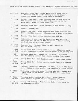
Typed transcription of the farm diary of Zabud MacKay (Malagash)
Nova Scotia Department of Agriculture and Marketing 1943 organizational chart
Sketch of farm at Valley Station [Nova Scotia]
Sketch of some coal and iron areas in Kemptown, Colchester County, Nova Scotia
Sketch of a woodlot in Truro, Nova Scotia
Double sided survey, Truro, Nova Scotia
Nova Scotia Agricultural College 1983-84 vocational and continuing education calendar
Part of Nova Scotia Agricultural College archival reference collection
1987 Nova Scotia Agricultural College convocation program
Part of Nova Scotia Agricultural College archival reference collection
Part of Nova Scotia Agricultural College archival reference collection
Dr. Richard Florizone : 2013 Dalhousie University Presidential Installation, October 4, 2013
1992 Nova Scotia Agricultural College convocation program
Part of Nova Scotia Agricultural College archival reference collection
Dalhousie University Faculty of Agriculture 2014-15 academic calendar
Part of Dalhousie University Faculty of Agriculture reference collection
"This is Agriculture" 2014-2019 Dalhousie University Faculty of Agriculture strategic plan
Part of Dalhousie University Faculty of Agriculture reference collection
"why agriculture" 2020-2025 Dalhousie University Faculty of Agriculture strategic plan
Part of Dalhousie University Faculty of Agriculture reference collection
2013 Dalhousie University Faculty of Agriculture Spring convocation program
Part of Dalhousie University Faculty of Agriculture reference collection
2014 Dalhousie University Faculty of Agriculture Spring convocation program
Part of Dalhousie University Faculty of Agriculture reference collection
2023 Dalhousie University Faculty of Agriculture Spring convocation program
Part of Dalhousie University Faculty of Agriculture reference collection
Nova Scotia Agricultural College engineering division 1939 annual report
Nova Scotia Agricultural College engineering division 1947 annual report
Site plan for the Cox Institute building extension