Item is a drawing showing the properties bordered by Bishop Street, Hollis Street, Salter Street, and Water Street in Halifax, Nova Scotia. The drawing shows all of the buildings that are located in this area, including the A. Keith & Son Ltd. building.
Item consists of the plan of lands at Sackville, Nova Scotia owned by George W. C. Oland as surveyed by R. W. MacKenzie. The property was located between the Lucasville Road, Old Windsor Road, the new Windsor Road and Webber's Lake.
Item is a map showing the locations of the mill construction; ruins of the old brick kilns; the clay shed; the new brick kilns; pipe drying; power house and machinery department near the Park Road address.
Item is a drawing of the proposed location of the former archives building (now the Chase Building) on Dalhousie University's Studley campus, showing ground elevations.
Item is map drawn by H.R. Theakston, University Engineer, showing Dalhousie and other associated buildings on and near both Studley Campus and Carleton Campus. The drawing includes a key indicating the names of both existing and proposed buildings.
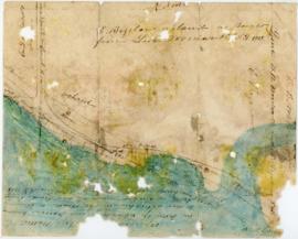
File contains proposed building site plans for Studley Campus drawn by H.R. Theakston, university engineer, as well as topographical maps of the Studley Estate prior to Dalhousie construction, including one created by engineering students. There are also several maps dating between 1922-1928 showing the campus's development.
Item is map drawn by H.R. Theakston, University Engineer, showing Dalhousie and other associated buildings on and near both Studley Campus and Carleton Campus. The drawing includes a key indicating the names of both existing and proposed buildings. It was originally made on May 14, 1924 and revised on June 30, 1925.
File comprises unrealized aerial perspective and site plan drawings for a future medical school at Dalhousie. There are also two plans of Studley campus showing the potential site for the new King's College buildings.
This is a map drawn by the Engineer's Office on September 15, 1913, of the Halifax Harbour - waterfront plan from Bishop Street to Point Pleasant Park and includes proposed changes to the waterfront.
File contains hand-drawn and printed maps of coal fields and designated areas, including Pictou coal fields; the Mining Association area; Cape Breton Company's areas; Albion Mines; Stellar Mine; Fraser Oil-Coal Mines; Intercolonial Coal Mining Company property; East River Mining Company area; Acadian Coal Company areas; and the Halifax Company Ltd.
Collection contains three historic maps collected by George Burden. The maps depict Cape Breton and Louisbourg, Nova Scotia. Burden acquired the maps from Zwicker's Gallery in Halifax, Nova Scotia.
Item is a map of the harbour of present-day Halifax, Nova Scotia created in 1779 by Joseph-Bernard de Chabert. The map was commissioned by Antoine de Sartine. Depths shown by soundings.
Item is a hand-coloured engraving of Cape Breton extracted from Atlas minimus, or, A new set of pocket maps of the several empires, kingdoms and states of the known world, published in 1758 by John Gibson and Emmanuel Bowen. The map appeared on page 46 of the book.