
Plan of the city and Harbour of Louisbourg

Chart of the Magdalen Islands in the Gulf of St. Lawrence, surveyed in 1765

Transparency relief map of Sable Island

Map of Musquodoboit Harbour Rural Telephone Company lines

Urban context

Plan of Studley Estate, site of Dalhousie University

Plan de la Baye de Chibouctou
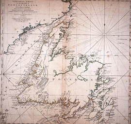
Chart of the Island of Newfoundland

Chart of the harbour of Halifax in Nova Scotia

Plan du port de Chibouctou à la côte de l'Acadie avec les côtes voisines

Map of Broughton Mutual Telephone Company's telephone line

Transparency relief map of Sable Island

Map of Africville

Dalhousie University grounds and buildings : erected and proposed
![Ground plan of Dalhousie University : [map]](/uploads/r/dalhousie-university-archives/0/a/8/0a834f8be003875dbec4cda568fa7e0a24fae39ff5f4cfbb41c3d54d5495bd16/83655f0e-ef17-4831-90a0-73b6ffee38ca-UA-3_487_3_8_142.jpg)
Ground plan of Dalhousie University : [map]

Map of Beaver Bank Rural Telephone Company's telephone line

Proposed location for the Archives building on Studley campus

Karte von dem Ostlichen-Stucke von Neu Frankreich oder Canada

Transparency map of continental shelf off Nova Scotia and Sable Island

Plan showing properties bounded by Bishop, Hollis, Salter & Water Streets
![Proposed rezoning of lands as requested by Dalhousie College and University : [map]](/uploads/r/dalhousie-university-archives/8/6/1/861e617d5c96adf38c584d108c62d54870ae9f68c9c916a83c380a66ad409665/55aba0d1-efab-43d7-bbbd-aef7f5557f2a-UA-3_487_3_9_142.jpg)
Proposed rezoning of lands as requested by Dalhousie College and University : [map]

Map of Brule Mutual Telephone Company's telephone line

Map of Petpeswick Harbour Mutual Telephone Company's telephone line

Dalhousie University grounds and buildings : erected and proposed