Showing 4 results

Archival Description
Oland and Son fonds Sackville (N.S.) With digital objects
Print preview View:

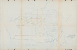
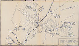
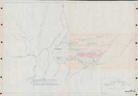
Sketch showing various properties in Upper Sackville, Nova Scotia

Item is a map of properties in Upper Sackville, Nova Scotia. The properties include properties owned by William Grennan; Associated Properties Limited; Herbert A. Wambolt; Mary E. O'Donnell; Mellish; James Hamilton; Oland's Brewers Grain & Yeast Limited; Sidney C. Oland; Valleyfield Farm; Granville Ellis; North American Mobile Homes Limited; Francis J. Dean; Harold T. Barrett; and Thomas J. Bullpit. The properties shown are bordered by Route No. 1, Public Highway, and the Dominion Atlantic Railway. The drawing was produced by Servant, Dunbrack & McKenzie Ltd.

Sketch of lots on Windsor Road in Upper Sackville, Nova Scotia

Item is a map showing properties along Windsor Road in Upper Sackville, Nova Scotia. The drawing shows properties belonging to Lewis Leroy Maxwell; John Gray; H. J. Fenerty; Elizabeth Grace; Ronald Maxwell; Cora Bambrick; Clarence Maxwell; Graham Helfer; Olands; Arnold Shankel; John Thomas; and Charles E. MacCulloch. The drawing was produced by Servant, Dunbrack & Mackenzie Ltd.

Boundary & topographic map showing the Lindwood farm land holdings at Sackville, Halifax Co., N.S.

Item is a boundary and topographic map of the Lindwood Farm holdings in Sackville, Nova Scotia. The map shows properties owned by MacCulloch; Lindwood Farms; G. Heffler; Moirs; Ellis Bros.; Thomas; R. Heffler; Thomas; Oliver; A. Shankel; Wm. Davis; Kelsie; Wyse; Lively; Carmichael; Kelly; Charles Goffe; Ed. Ford; Mrs. Hilchie; Wambolt; and Hopkins. The drawing was produced by F. G. Nolan.