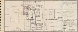
Item is a drawing of floor plans of Unit C of the A. Keith and Son brewery. The drawing shows floor plans of the third and fourth floors of Unit C and some of Unit B. The drawing was originally bound in a booklet with other drawings of the building. The drawing was produced by Hancock Little Calvert Associates.
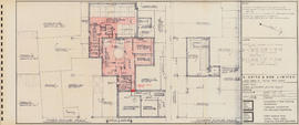
Item is a drawing of floor plans of Unit C of the A. Keith and Son brewery. The drawing shows floor plans of the third and fourth floors of Unit C and some of Unit B. Certain areas and pathways are highlighted in red coloured pencil. The drawing was originally bound in a booklet with other drawings of the building. The drawing was produced by Hancock Little Calvert Associates.
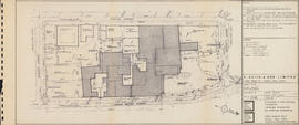
Item is a drawing of the site of the A. Keith and Son brewery. The drawing shows all of the properties surrounded by Bishop, Hollis, Salter, and Lower Water Streets with approximate measurements. The drawing was originally bound in a booklet with other drawings of the building. The drawing was produced by Hancock Little Calvert Associates.
This file consists of share valuation of Olands Brewery Limited; A. Keith and Sons Limited; Chester Hotels Limited; Keith Hall Investments Limited; Lindwood Holdings Limited; Oland Investments Limited and Culverwell Holdings Limited.
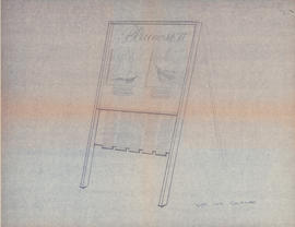
Item consists of two copies of proposed schematic diagram of the electrical distribution of the Bluenose II. The drawing is labelled "Sketch No H.S.L.-BL/EL-18." The drawing was completed on January 29th, 1965 for Halifax Shipyards. One copy of the drawing includes a table of estimated sea loads that is not present on the other copy
File consists of the plans showing the properties that border Lindwood Farms in Sackville, Nova Scotia. These borders include properties owned by Moirs; Hefler Lumber; Wambolt; Hopkins; Hilchie; Davis; Kelsie and Lively.
File consists of the plan of survey for the property owned by Lindwood Holdings Limited on Young Avenue, Ivanhoe Street and Atlantic Street as surveyed by Wallace MacDonald Surveys Limited.
File consists of the plans for the mini hydro power development on the Sackville River, Nova Scotia, McCabe Lake storage dam location drawn by L. E. Powell and Company limited as the engineers and builders.
Item is a drawing showing the properties bordered by Bishop Street, Hollis Street, Salter Street, and Water Street in Halifax, Nova Scotia. The drawing shows all of the buildings that are located in this area, including the A. Keith & Son Ltd. building.
Item is a map of properties in Upper Sackville, Nova Scotia. The properties include properties owned by William Grennan; Associated Properties Limited; Herbert A. Wambolt; Mary E. O'Donnell; Mellish; James Hamilton; Oland's Brewers Grain & Yeast Limited; Sidney C. Oland; Valleyfield Farm; Granville Ellis; North American Mobile Homes Limited; Francis J. Dean; Harold T. Barrett; and Thomas J. Bullpit. The properties shown are bordered by Route No. 1, Public Highway, and the Dominion Atlantic Railway. The drawing was produced by Servant, Dunbrack & McKenzie Ltd.
Item consists of a survey plan of the property owned by S. C. Oland on the corner of Pleasant Street and Central Street in Chester, Lunenburg County, Nova Scotia as surveyed by Errol Hebb.
Item consists of the plan of survey for the property owned by Richard H. Oland on Tremont Street in Chester, Nova Scotia and was surveyed by Kyle Harrington.
File consists of two plan surveys of property in Seabright. Plan survey of lands of Lindwood Holdings Limited, Seabright, Lot 15 and was surveyed by Wallace MadDonald and Lively Limited in 1982 and Plan survey of lands of Lindwood Holdings Limited, Seabright, Lot 6A, 7 and 7B, formerly Graham K. Brundige property and was surveyed by Thompson and Purcell Surveying Limited in 1981.
File consists of a survey plans of the property known as Block - WK - Bluenose Wharf owned by A. Keith & Son Limited as surveyed by Roy. A. Dunbrack and the Canadian Plant and Process Engineering Limited (CPPE) plan.
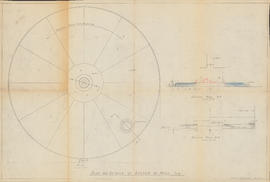
Item is a drawing of the bottom of a mash tub. The drawing include a plan view of the tub (scale 1" = 1') and two cross-section views (scale 3" = 1'). The drawing was drawn by R. J. Fitzpatrick in Halifax, Nova Scotia.
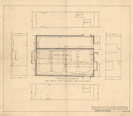
Item is a drawing of the plan and elevations of a room in the basement of a plant in Halifax, Nova Scotia belonging to A. Keith and Son Ltd. The drawing was produced by H. E. Weeks & R. J. Fitzpatrick.
Item consists of two copies of a technical drawing of the plan and elevations of a room in the basement of a plant in Halifax, Nova Scotia belonging to A. Keith and Son Ltd. The drawing was produced by C. & J. Wilson.
Files consists of one photograph of Col. Sidney C. Oland at a dinner table surrounded by unidentified people and one photograph of Col. Sidney C. Oland with an unidentified gentleman, this photograph was used in the February, 1954 issue of Brewers Digest.
Item consists of a photograph of Sea Rangers Pat Power of Lunenburg, Sandy Le Baron of Montreal and Estelle Forbes of Lunenburg being given a tour of the Bluenose II by First Mate Oddmund Skodje.
File consists of two photographs of the group "The Townsman", who played at the reception after the launching of the Bluenose II in Lunenburg, Nova Scotia. The group included Michael Stanbury, shown in the photograph with the guitar; he is the son of Amadita and grandson of Col. Sidney Oland.
File consists of three photographs of the winner of the Bluenose Futurity Trophy, Mr. L. Neill with horse "The Dairyman"; included in the photographs: Captain John Cruickshank; Mr. Jimmy Ferguson and Mr. John Cruickhank Jr.