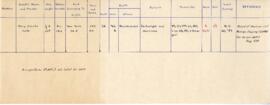
File contains a receipt book for travel and communications expenses from May to September. Locations include Kentville, Halifax, Bathurst, New Glasgow, Sydney, Charlottetown, Moncton, and Woodstock. Financial charges include trains, cars, buses, wires, phone calls, and permits.
Item is an historic map of depicting Cape Breton Island and the surrounding area. The map shows all of Cape Breton, including Canso Isles, Chedabucto Harbour, Bra d'Or Lake, St. Anne, and Cape North.
Item is a hand-coloured engraving of Cape Breton extracted from Atlas minimus, or, A new set of pocket maps of the several empires, kingdoms and states of the known world, published in 1758 by John Gibson and Emmanuel Bowen. The map appeared on page 46 of the book.
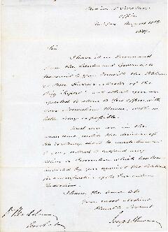
File contains a letter from Joseph Howe to D.O.C. Madden of Arichat, Nova Scotia, written on 10 August 1849. The letter discusses a petition from Peter Furrier, Master of the Brig Superb, to have his vessel released from quarantine.
File contains hand-drawn and printed maps of coal fields and designated areas, including Pictou coal fields; the Mining Association area; Cape Breton Company's areas; Albion Mines; Stellar Mine; Fraser Oil-Coal Mines; Intercolonial Coal Mining Company property; East River Mining Company area; Acadian Coal Company areas; and the Halifax Company Ltd.
One man with handlebar moustache, high collar and pin in lapel; bust. Plate inscribed: "Williams", but envelope annotated: "McWilliams", as is plate: PC-2-27-107 of same person
One young man seated and one young man standing beside him wearing uniform caps and ribbons on pins which read in part: "St Anthony's …CMBA Sydney Mines, CB …"