A group of men and boys, wearing hats and caps, standing in the foreground in front of the area destroyed in New Glasgow by the fire of April 19, 1874. Two horse-drawn carriages are visible at the edge of the group. Print copy also available: PC-2-334-6
A group of men, women and children, wearing hats and caps, standing in the foreground in front of the area destroyed in New Glasgow by the fire of April 19, 1874. A fire-carriage is in the centre of the group
View of New Glasgow after the fire of April 19, 1874. One complete block has been destroyed down to the foundations, along with portions of two others. Several firemen and a few other men are surveying the destruction. A factory chimney stands at one edge. One a fence three advertisements are visible, two of which read: "Use Brown's Bronchial …", "Use household panacea …"
View of New Glasgow after the fire of April 19, 1874. One complete block has been destroyed down to the foundations, along with portions of two others. Print copy also available: PC-2-334-5
View of New Glasgow from the surrounding countryside, prior to the fire of April 19, 1874. A church visible at one edge. Print copy is also available: PC-2-334-13
View across the harbour of the town of Pictou, taken from Pictou Landing where a sailing ship is partially visible at a wharf. Print copy is included. Safety negative and print copy also filed as: PC-2-335-6. Larger print copy is available: PC-2-334-14
Steam Ship "East Riding" with Carmichael Shipyards in background, with wooden houses and a church on the hill behind. Print copy is available: PC-2-334-8
Street scene with a confectionery store on one corner and a four storey building with balconies, the "Norfolk Hotel" on the opposite side. Cars are driving on the left-hand side of the street. Print copy is also available: PC-2-334-25
View of a mine site after an explosion. Damaged mine buildings and a pile of coal are in the background. Tree stumps and logs litter the area in front. A safety negative is also included. Small print copy and safety negative filed as: PC-2-335-7
Landscape with wooded area in background and cleared land littered with fallen trees and logs in the foreground. A large pulley wheel is lying in the centre, possibly ready to be erected. Three men are standing in the background
Landscape looking down on a street with many trees on both sides on which three carriages are driving. The sign on the closest building is thought to read: "LIVERY STABLE"
Main Street in Antigonish showing buildings on both sides and several people walking or standing in it. The two closest buildings have signs reading" "Palace Clothing Company" and "T. J. Bonner". Print copy is available: PC-2-333-91
Seven views of buildings and landscapes taken in Antigonish, laid out on a cloth-covered table with greenery and flowers between them, and a card annotated: "Souvenir of Antigonish". This may possibly have been taken to produce a postcard
File contains photographs of lanes and pre-revolutionary Charleston architecture; the countryside near Charleston; the Town of Ninety-Six; "up country"; 69 Fox Street; St George's Church, London, UK; and Mahone Bay, Nova Scotia.
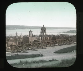
Item is a hand coloured glass plate lantern slide of Halifax, Nova Scotia seen from Citadel Hill. The photograph shows Citadel Hill cannons in the foreground and the Halifax Town Clock in the middleground. The photograph was taken by Byron Ulric Hatfield sometime in the early twentieth century.
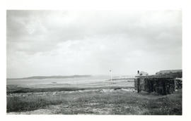
Item is a photograph of the site of the New Englander's landing in 1745, and later, in 1758, the landing of Amherst with his artillery stores. The birds visible in The Barachois on the left are cormorants.
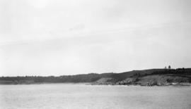
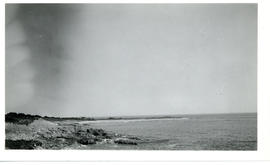
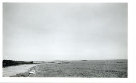
Item, a photograph, includes White Point, which is the long, low spit in the background. The small point in the middle distance is shown on old maps as Gull Point.
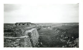
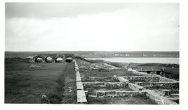
Item, a photograph, is taken from the roof of a casement in King's Bastion. The foundation of the fort's barracks are visible in the foreground, the ruins of more casements are visible in the right foreground, and beyond the casements are the roofs of the museum and caretaker's house.
Item is a photograph showing the foundation of the fort's barracks. The ruined casements visible in the background show the original height of the ramparts.
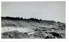
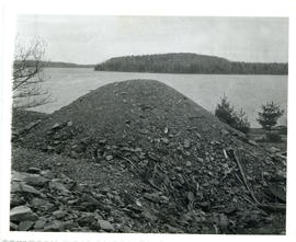
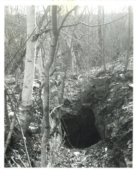
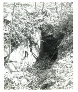
Item, a photograph, is a duplicate of material in MS-2-202, Box 55, Folder 22, Item 18 in subseries Thomas Head Raddall's loose photographs. The photograph was taken by Hugh Byrne. A few years after the photograph was taken, most of the tailings at the Molega mines were trucked away to help form part of a new motor road into Kejimkujik Park.
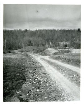
Item, a photograph, is a duplicate of material in MS-2-202, Box 55, Folder 22, Item 18 in subseries Thomas Head Raddall's loose photographs. The photograph was taken by Hugh Byrne.
Item, a photograph, is a duplicate of material in MS-2-202, Box 55, Folder 22, Item 18 in subseries Thomas Head Raddall's loose photographs. The photograph was taken by Hugh Byrne.
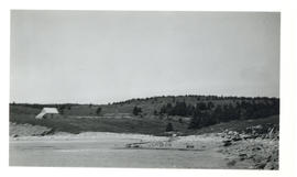
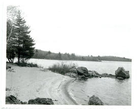
Item, a photograph, is a duplicate of material in MS-2-202, Box 55, Folder 22, Item 18 in subseries Thomas Head Raddall's loose photographs. The photograph was taken by Hugh Byrne. Ponhook Lake is visible in the background.
Item, a photograph, is a duplicate of material in MS-2-202, Box 55, Folder 22, Item 18 in subseries Thomas Head Raddall's loose photographs. The photograph was taken by Hugh Byrne.
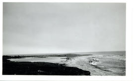
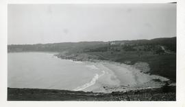
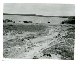
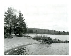
Item, a photograph, is a duplicate of material in MS-2-202, Box 55, Folder 22, Item 18 in subseries Thomas Head Raddall's loose photographs. The quartz sand results from ore crushed at Molega. The beach was once a busy steamboat landing, but was later used as a bathing beach.
Item, a photograph, is a duplicate of material in MS-2-202, Box 55, Folder 22, Item 18 in subseries Thomas Head Raddall's loose photographs. The quartz sand on the beach results from ore crushed at Molega. The beach was once a busy steamboat landing, but was later used as a bathing beach.
Item, a photograph, is a duplicate of material in MS-2-202, Box 55, Folder 22, Item 18 in subseries Thomas Head Raddall's loose photographs. The photograph was taken by Hugh Byrne. The mine is located just behind Molega Beach.
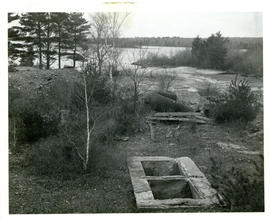
Item, a photograph, is a duplicate of material in MS-2-202, Box 55, Folder 22, Item 18 in subseries Thomas Head Raddall's loose photographs. The home was built during the gold rush days. A couple of stone steps from the house are visible in the foreground, while the well and an apple tree from the yard are visible in the background.
Item, a photograph, is a duplicate of material in MS-2-202, Box 55, Folder 22, Item 18 in subseries Thomas Head Raddall's loose photographs. The photograph was taken by Hugh Byrne.
Item, a photograph, is a duplicate of material in MS-2-202, Box 55, Folder 22, Item 18 in subseries Thomas Head Raddall's loose photographs. The photograph was taken by Hugh Byrne.
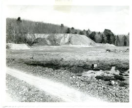
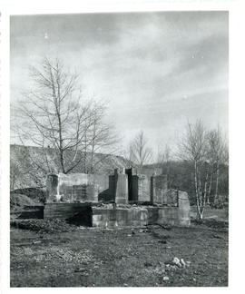
Item, a photograph, is a duplicate of material in MS-2-202, Box 55, Folder 22, Item 18 in subseries Thomas Head Raddall's loose photographs. The stamp mill at Molega that was last used in the 1930's. A mound of tailings is visible in the background.
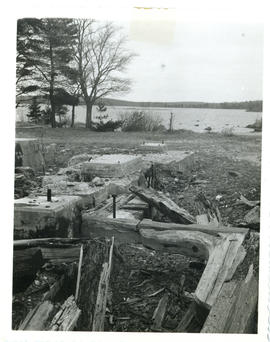
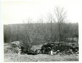
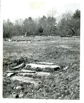
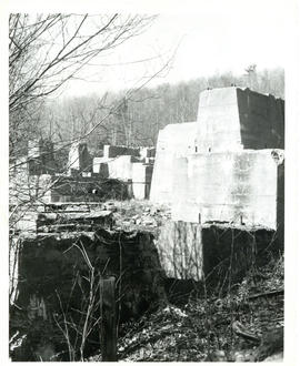
Item, a photograph, is a duplicate of material in MS-2-202, Box 55, Folder 22, Item 18 in subseries Thomas Head Raddall's loose photographs. The photograph was taken by Hugh Byrne. The foundations were built in the 1930's, and are evidence of one of the last attempts at gold mining in the area.