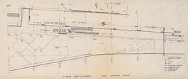
Item is a photocopy of a map of an area on the St. Lawrence River. The map is identical to MS-4-135, Oversized Folder 3, Item 2, but without the handwritten notes.
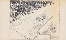
Item is a photocopy of a map of Montreal and the Saint Lawrence River and Montreal, including Ile Sainte-Helene, Ile Notre Dame, and a ship berthing area. The original map was produced by the Canadian Corporation for the 1967 World Exhibition.
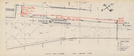
Item is a photocopy of a map of an area on the St. Lawrence River. There are notes written on the map in red that indicate the position of the Bluenose II and other things (possibly other ships).