Photographs from "What's Brewing at Oland's?" : Volume 5, Number 5, 1964
- MS-4-135, Box 183, Folder 51
- File
- 1964
Part of Oland and Son fonds
75 results with digital objects Show results with digital objects
Photographs from "What's Brewing at Oland's?" : Volume 5, Number 5, 1964
Part of Oland and Son fonds
Photographs from "What's Brewing at Oland's?" : Volume 5, Number 6, 1964
Part of Oland and Son fonds
Photographs from "What's Brewing at Oland's?" : Volume 6, Number 2, 1965
Part of Oland and Son fonds
Photographs from "What's Brewing at Oland's?" : Volume 6, Number 5, 1965
Part of Oland and Son fonds
Photographs from "What's Brewing at Oland's?" : Volume 6, Number 6, 1965
Part of Oland and Son fonds
Photographs from "What's Brewing at Oland's?" : Volume 7, Number 2, 1966
Part of Oland and Son fonds
Photographs from "What's Brewing at Oland's?" : Volume 7, Number 3, 1966
Part of Oland and Son fonds
Photographs from "What's Brewing at Oland's?" : Volume 7, Number 5, 1966
Part of Oland and Son fonds
Photographs from "What's Brewing at Oland's?" : Volume 8, Number 1, 1967
Part of Oland and Son fonds
Photographs from "What's Brewing at Oland's?" : Volume 8, Number 2, 1967
Part of Oland and Son fonds
Photographs from "What's Brewing at Oland's?" : Volume 8, Number 3, 1967
Part of Oland and Son fonds
Photographs from "What's Brewing at Oland's?" : Volume 8, Number 4, 1967
Part of Oland and Son fonds
Part of Oland and Son fonds
Photographs of Olands buildings
Part of Oland and Son fonds
Photographs of Olands construction
Part of Oland and Son fonds
Photographs of Ayrshire Breeders Association
Part of Oland and Son fonds
Photographs of beer making processess in the brewery
Part of Oland and Son fonds
Part of Oland and Son fonds
Photographs of choir director, Charles Underwood
Part of Oland and Son fonds
Part of Oland and Son fonds
Photographs of repairs needed for Keith Hall
Part of Oland and Son fonds
Photographs of the Bluenose II sailing with the Tall Ships 1984
Part of Oland and Son fonds
Photographs of the Brewers convention
Part of Oland and Son fonds
Photographs of the Brewers convention
Part of Oland and Son fonds
Photographs of the building of the hull of the Bluenose II
Part of Oland and Son fonds
Photographs of the celebration launching of the Bluenose II in Lunenburg
Part of Oland and Son fonds
Part of Oland and Son fonds
Photographs of the historic members of the Olands company
Part of Oland and Son fonds
Photographs of the new tanks at Olands
Part of Oland and Son fonds
Photographs of the Sea Rangers on board the Bluenose II
Part of Oland and Son fonds
Photographs of the United States Brewers Foundation Convention, Los Angeles, 1954
Part of Oland and Son fonds
Photographs of unidentified Olands hockey team players
Part of Oland and Son fonds
Photographs of unidentified Olands soccer team players
Part of Oland and Son fonds
Photographs of unidentified staff from the Olands company used as public relations photographs
Part of Oland and Son fonds
Photographs of unidentified staff from the Olands company used as public relations photographs
Part of Oland and Son fonds
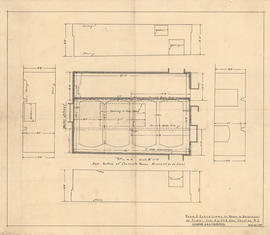
Plan & elevations of room in basement of plant for Keith & Son
Part of Oland and Son fonds

Plan & elevations of room in basement of plant for Keith & Son
Part of Oland and Son fonds
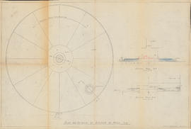
Plan and details of bottom of mash tub
Part of Oland and Son fonds
Plan of survey for properties of Olands at Northfield, Hants County, Nova Scotia
Part of Oland and Son fonds
Plan of survey of Block - WK - Bluenose Wharf, property of A. Keith & Son Limited
Part of Oland and Son fonds
Plan of survey of lands of Lindwood Holdings Limited in Seabright, Halifax County, Nova Scotia
Part of Oland and Son fonds
Plan of survey of lands of Richard H. Oland, Tremont Street, Chester, Lunenburg County, Nova Scotia
Part of Oland and Son fonds
Part of Oland and Son fonds
Plan showing lands owned by Oland's Brewers Grain & Yeast Limited and Sidney C. Oland
Part of Oland and Son fonds
Plan showing Lot D1 of the Carl Hamilton property for transfer to Lindwood Farms
Part of Oland and Son fonds

Plan showing properties bounded by Bishop, Hollis, Salter & Water Streets
Part of Oland and Son fonds
Plans for Oland & Son buildings
Part of Oland and Son fonds
Part of Oland and Son fonds
Part of Oland and Son fonds
Part of Oland and Son fonds