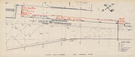
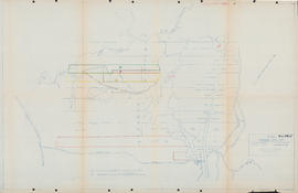
Item is a photocopy of a map of an area on the St. Lawrence River. There are notes written on the map in red that indicate the position of the Bluenose II and other things (possibly other ships).
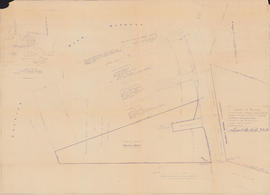
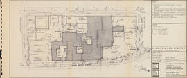
Item is a reproduction of a map of properties and wharves on the waterfront along Lower Water Street in Halifax, Nova Scotia. The properties are all labeled with names and numbers.
Item is a drawing of pattern arrangements for a pallet loader. The drawing includes diagrams for pallets and tables with more information. The drawing was produced by Mathews Conveyor Co. Ltd. for Oland & Son Ltd.
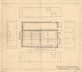
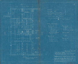
Item is a drawing of the plan and elevations of a room in the basement of a plant in Halifax, Nova Scotia belonging to A. Keith and Son Ltd. The drawing was produced by H. E. Weeks & R. J. Fitzpatrick.
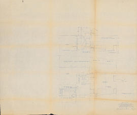
Item consists of two copies of a technical drawing of the plan and elevations of a room in the basement of a plant in Halifax, Nova Scotia belonging to A. Keith and Son Ltd. The drawing was produced by C. & J. Wilson.
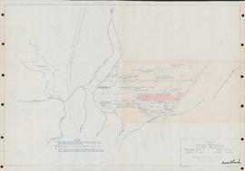
Item is a map showing a survey of Provincial Water Grant No. 20618, in the Back Harbour of Chester, Lunenburg, Nova Scotia. The surveys were conducted on June 10th and 11th, 1954 by Errol B. Hebb of Bridgewater, Nova Scotia. The map shows the shoreline along Shore Road, including wharves and lots currently or formerly owned by Clarissa Gibbs, James M. Allen, Andrew Anderson, C. Orchiltree MacDonald, E. R. Paxton, Elizabeth Allen, Verginia M. Allen, Mary L. Ritchie, Florence B. McCurdy, and William F. Bryans. There is also a small map of the Chester area inset in the upper left corner of the drawing.
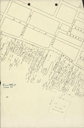
Item is a drawing showing the properties bordered by Bishop Street, Hollis Street, Salter Street, and Water Street in Halifax, Nova Scotia. The drawing shows all of the buildings that are located in this area, including the A. Keith & Son Ltd. building.
Item is a photograph of the crew of the Bluenose II. Back Row L-R: Captain Ellsworth Coggins, Steward (unknown), Cook Kenny Beckford, Bosun William Snow, Engineer John Weeks, Mate (unknown). Front Row: Jim Johnson, Alex Hartley, Bob Keddy, unknown.
File contains two copies of a drawing of proposed modifications to the saloon and hold of the Bluenose II. The drawing was produced by Sparkman & Stephens, Inc. from New York City. The drawing shows a floor plan of the area as well as a side view of the rooms and stairs.
Item consists of two copies of proposed schematic diagram of the electrical distribution of the Bluenose II. The drawing is labelled "Sketch No H.S.L.-BL/EL-18." The drawing was completed on January 29th, 1965 for Halifax Shipyards. One copy of the drawing includes a table of estimated sea loads that is not present on the other copy
Item is a blueprint of a reinforced concrete for a proposed mezzanine for Oland & Son. The drawing was produced by L. André Glen on March 6th, 1954, and was revised on March 22nd, 1952.
Item is a drawing of the site of the A. Keith and Son brewery. The drawing shows all of the properties surrounded by Bishop, Hollis, Salter, and Lower Water Streets with approximate measurements. The drawing was originally bound in a booklet with other drawings of the building. The drawing was produced by Hancock Little Calvert Associates.
Item is a map of land in Middle Sackville, Nova Scotia surveyed for Clayton Developments Ltd. The map shows coordinates and elevations of the land. The map was produced by Servant, Dunbrack & McKenzie Ltd.
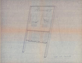
Item is a drawing of a sandwich board sign. The drawing include measurements and information about materials. The sign is a photo display for the Bluenose II, possibly for Expo 67.
Item is a map showing properties along Windsor Road in Upper Sackville, Nova Scotia. The drawing shows properties belonging to Lewis Leroy Maxwell; John Gray; H. J. Fenerty; Elizabeth Grace; Ronald Maxwell; Cora Bambrick; Clarence Maxwell; Graham Helfer; Olands; Arnold Shankel; John Thomas; and Charles E. MacCulloch. The drawing was produced by Servant, Dunbrack & Mackenzie Ltd.
Item is a map of properties in Upper Sackville, Nova Scotia. The properties include properties owned by William Grennan; Associated Properties Limited; Herbert A. Wambolt; Mary E. O'Donnell; Mellish; James Hamilton; Oland's Brewers Grain & Yeast Limited; Sidney C. Oland; Valleyfield Farm; Granville Ellis; North American Mobile Homes Limited; Francis J. Dean; Harold T. Barrett; and Thomas J. Bullpit. The properties shown are bordered by Route No. 1, Public Highway, and the Dominion Atlantic Railway. The drawing was produced by Servant, Dunbrack & McKenzie Ltd.
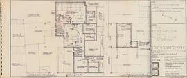
Item is a drawing of floor plans of Unit C of the A. Keith and Son brewery. The drawing shows floor plans of the third and fourth floors of Unit C and some of Unit B. The drawing was originally bound in a booklet with other drawings of the building. The drawing was produced by Hancock Little Calvert Associates.
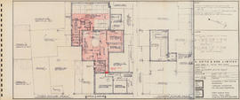
Item is a drawing of floor plans of Unit C of the A. Keith and Son brewery. The drawing shows floor plans of the third and fourth floors of Unit C and some of Unit B. Certain areas and pathways are highlighted in red coloured pencil. The drawing was originally bound in a booklet with other drawings of the building. The drawing was produced by Hancock Little Calvert Associates.
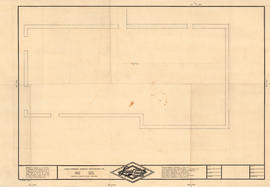
Item is an unfinished technical drawing showing what could be the walls of a room or building. The drawing is drawn on paper with the Liquid Carbonic Canadian Corporation's logo on it.
![Nova Scotia Brewery : [poster]](/uploads/r/dalhousie-university-archives/d/3/5/d35c0eab0a046670e7cf4026a362b2c33d5efd8a4e51a2350f433521c12231f2/MS-4-135_2019_046_OS46_access_142.jpg)
![Pallet loader semi auto pattern arrangements : [drawing]](/uploads/r/dalhousie-university-archives/8/6/6/86618b35ce6c6243a8e646c6f1c71ca5ae1154080d7ec88c3e29bc2e0fb9c4ba/ms-4-135_os21_001_142.jpg)


![Semi automatic pallet loader arrangement : [drawing]](/uploads/r/dalhousie-university-archives/7/0/c/70cf0112291bf52860ad615278421cc950fac95f6961b830ff8567e57ae76816/ms-4-135_os21_002_142.jpg)


![The Army & Navy Brewery : [poster]](/uploads/r/dalhousie-university-archives/c/c/6/cc626d1963eb7f157989f89a4768f0fbbdbbb707d1bf424edcd40ec52000ddf7/MS-4-135_2019_046_OS47_access_142.jpg)
![The Army & Navy Brewery : [poster]](/uploads/r/dalhousie-university-archives/3/f/5/3f51dbbc5c14dc080ba94339d85b6ee461d18fe2babbd336740bcae55b7813e0/MS-4-135_2019_046_OS48_access_142.jpg)