- MS-4-203, SF Box 46, Folder 8
- Item
- 1848-1857
Ledger 1848-1857 including accounts of the Schooner (later brigantine) Samuel Campbell
Melanson, [Augustine?]
14 results with digital objects Show results with digital objects
Melanson, [Augustine?]
Halliburton, Brenton, Sir, 1774-1860
Letter from A.C. Macdonald to Liberal candidate Robert Murray regarding 1847 election meetings
MacDonald, A.C.
Letter to A.M. Uniacke from John Inglis, third bishop of Nova Scotia
Uniacke, A.M., 1808-1895
Outram, Joseph, fl. 1844
Poetry copybook of Colin Campbell
Campbell, Colin, 1822-1881
Letter from Lewis Williams to John McGregor
McGregor, John
Commonplace book of Amelia Davis
Darby, Amelia Davis, 1823-1904
Notebook of George Renny Young
Young, George Renny, 1802-1853
Crane, Silas H.
Deed for sale of land in Granville, Nova Scotia from Ann Hughes to Abel Sands
Hughes, Ann
William and Robert Lawson's business ledger (1829-1833) and journal (1842-1845)
Lawson, William
Letter from Jonathan Sewell to his daughters, Maria and Henrietta
Sewell, Jonathan, Justice, c. 1766-1839
Warrant for payment issued to Peter Turquand and signed by George Ramsay, 9th Earl of Dalhousie
Turquand, Peter
Letter from Lord Dalhousie to W. Smith
Smith, W., fl. 1823
Deed of land transfer from Leonard Baker to Jacob and Frederick Publicoffer
Publicoffer, Jacob and Frederick
James Miller's notes about surgical lectures given by Dr. Munro
Miller, James
Receipt book of Matthew Richardson
Richardson, Matthew
James Thom and Company insurance policy on the schooner Favourite
Thom, James and Company.
Register of farmers' cattle and sheep marks in Chester, Nova Scotia
Chester Municipality.
William Himsworth's purchase of the schooner Nine Sisters
Himsworth, William
Booth, Fredrick, 1806
Letter from Simeon Perkins to William Cahoon
Cahoon, William
Michie, John, fl. 1763
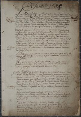
Item is a cartographic journal containing daily entries and twenty-five cartographic diagrams and topographical illustrations showing coastlines, elevations, distances (in leagues), water depths, capes, bays, rivers, inlets, islands and other geographical features.
From the accounts of the first few days, the jump off point must have been somewhere near Mahone Bay or Lunenburg, on the southern coast of Nova Scotia. Few observations are recorded during the first week; the aim seems to have been to reach an initial destination of Grand Manan Island. At this point, beginning on July 25, 1684, detailed observations are made of all islands, rocks, and other geographical objects, along with more specific information concerning water depths (given in braces), types of currents, prevailing winds, distances between landmarks (given in leagues), places of secure anchorage, danger zones, etc. Most of the observed areas are accompanied by topographical illustrations which depict not only the contours of the coastline, but also elevations from sea level.
The expedition proceeded from Grand Manan Island down into Passamaquoddy Bay (this is not named, but the St. Croix River is), then Northeast along the coast of New Brunswick to the entrance to the St. John River. At this point, the expedition encountered at least two British war vessels, equipped with cannons. An envoy from the expedition was sent to the British ships, apparently commanded by John Nelson, the nephew of the first proprietor of New Brunswick; assurances are exchanged, the envoy is returned, and the expedition again proceeds along its way. Much of this portion of the expedition was obscured by a dense and persistent thick fog which made the task of the cartographer at times impossible, as he frequently notes.
From St. John River, the expedition turned back again across the Bay of Fundy, along Long Island, down along the Western coast of Nova Scotia to Cape Sable. This destination is reached by July 31, 1684, and here some days are passed waiting out a violent storm. Another British ship is mentioned, though no contact was made. The coastline from Cape Sable all the way to Margaret's Bay is represented by numerous illustrations. The weather seems to have been more favourable, and much of the area was apparently uncharted.
This portion of the journey includes descriptions and illustrations of Cape Negro, Baye du Port Razor, Riv. des Jardins, Port Rosignol, Sable River, La Have Harbour, Mahone Bay (called here Mirligaich), Margaret's Bay, etc. The expedition continues from Margaret's Bay on to the Northeast, with observations of Cape Sambro, Riv. Chibouetou. Riv. Maganchis, Cape Thiodor, and it ends at St. Mary's River, on September 14, 1684.
Appended to the journal is a twelve page "Inventaire pour servir a l'armament et consommation du nav(igation)," in which a very detailed list of hundreds of items is presented. The two categories that receive the most attention are boat fixtures (e.g., sails, bowsprites, halyards, stays, topsails, masts, anchors, rope, riggings, etc.) and armaments (e.g., cannons, ammunitions, guns, other weapons, etc.). Surgical equipment is briefly mentioned. Extraneous observations are also included from time to time: an abundance of fish off Cape Forcheau; arborage and foliage on shore; disembarkments, during one of which one of the crew apparently attempted to desert.
Marianne (Ship)
Emily Bevan Harrington's university lecture and essay notes
Harrington, Emily Bevan
Sermons of Reverend Peter De LaRoche
De LaRoche, Peter, The Reverend, c. 1752-1795