Showing 294767 results

Archival Description
Print preview View:

27315 results with digital objects Show results with digital objects

Photographs of E. L. Eaton with his wooden chain display board

  • MS-14-69, PB Box 25, Folder 3, Items 1-3
  • File
  • 1983
File contains three photographs, two of E.L. Eaton with the wooden chains and board he carved and mounted and one close up photograph of the board with wooden chains. The photographs were taken in 1983 of the work done in 1981.

Agricultural correspondence collection

  • MS-14-7
  • Collection
  • 1881-1979
Collection contains correspondence and an article, some are from Nova Scotia Agricultural College principals, or faculty, topics cover early education, the Canadian fruit trade, and trotting.

Canadian agriculture collection

  • MS-14-8
  • Collection
  • [1900?]-[1999?]
Collection contains textual records, reports, and photographs related to Canadian agriculture. Topics include the development of agriculture in Canada, the banning of pesticides, the agricultural industry, exhibitions and garden clubs.

Development of a data processing strategy for the provincial government departments located in Truro, Nova Scotia / S.M. Katz

Item was prepared for : Department of Government Services, Province of Nova Scotia.
Purpose of this study was to provide an information system strategy to satisfy the known current and future needs of the government organizations located in Truro Nova Scotia :
The Nova Scotia Farm Loan Board,
Nova Scotia College of Agriculture,
The Department of Agriculture and Marketing,
The Nova Scotia Teacher's College and the
Department of Lands and Forests

Photograph of barley grown on farm of Alex McKay, esq. Lyons Brook, Pictou, County

Item is a photograph of barley grown on the farm of Alex McKay, esq. Lyons Brook, Pictou, Co. 1923. May have belonged to W.A. McKay (dairying) who graduated from the Nova Scotia Agricultural College in 1914. McKay. Depicted is Barley from a part of a field to which Malagash [Nova Scotia] potash land salt was applied and from a part of the same field with the same treatment except no Malagash potash land salt was applied.

Generator propeller

  • MS-14-86 - Museum / SLC exhibit case
  • Item
  • [1900-1999]
Item is a wooden generator propeller.

Atlantic Canada farm and rural life collection

  • MS-14-9
  • Collection
  • 1851-2004
Collection consists of material related to farm and rural life in Atlantic Canada. Including historical accounts of farm life and agricultural management in Atlantic Canada. Series include graphic materials, maps, surveys, and sketches of farms in Nova Scotia, and reports and diaries related to farm and rural life in Atlantic Canada. Series are arranged alphabetically and range between 1851-2004.

Sketch of some coal and iron areas in Kemptown, Colchester County, Nova Scotia

Item is a sketch of a survey of some coal and iron areas in Kemptown, Colchester County, Nova Scotia. It was surveyed for A.H. Learnment, et al., October 4th, 1905 by J.K. Eaton D.C.L.S. Scale 1":40.00 chains. Also shown are adjacent properties of J.H. McKay, Maple Leaf Prospecting Co., and J. McNaughton.

Sketch of property lying on the North side of the Intervale Road near I.R.C. Railway [Truro, Nova Scotia]

Item is a sketch of the properties lying on the North side of the Intervale Road near I.R.C. Railway crossing known as the Allan Loughead field [Truro, Nova Scotia]. Surveyed for the Hon. W.F. McCurdy, of Baddeck, Cape Breton. Truro, N.S. June 27, 1911 [by] J.K. Eaton, D.C.L. Surveyor. Scale 1":30'. Also shown are the property of Gov. Experimental Farm, Queen Street East or Intervale Road, the center of Logan's Gully, and the proposed new street. Adjacent properties are Miller, Mrs. Maud Work, Mrs. Adelaide Nowlin, and Wm.E. Logan. There is a handwritten note in pencil under the Surveyors label.

Double sided survey, Truro, Nova Scotia

Item is a double sided sketch of surveys. One side of the page has on the right, in ink, a sketch of Truro Market Property, surveyed for John A. McKenzie & Sons, June 3, 1905. Scale 1: 20 chains. The McKenzie house and Market are on Havelock street and Prince Street. Also shown are edging adjacent properties Allan Loughead and G.O. Fulton on Inglis Street. There is a blank space in the middle of the page and on the left is depicted Beaver Dam Brook passing through the properties of James Hennigar, Henry Miller, McLearn, Patterson, McCulloch, and nearby Dodds, Underwood, Robert Barr and Scott, and Russel Brook. There are pencil annotations as well. The other side shows sketched in ink the property of T.G. McMullen, Prince Street East, Truro, Nova Scotia. The ink notation says "known as the Craig Hat Factory. September 11, 1906. By J.K. Eaton, D.C.L.S. Scale 1":30'". Shows Prince Street crossing Munroe Street, along Brook to W. Archibald's line, the properties of Estate Samuel Rettie, Alvin Fulmore's lot. In pencil: "Sketch of same surveys made at Debert Station, for Charles [McElmon?] January 12, 1906, this sketch made May 30th, 1906.

Field notebooks and soil profile descriptions in Nova Scotia

File contains field notebooks and soil profile descriptions in Nova Scotia from the 1940s to the 1960s. The field notebooks are initialed J.D.H. for Hants county, one initialed A.M.M. covering Berwick and Annapolis County, one initialed D.C.M. / C.B. covering Hants County, Debert, Truro, Upper Kennetcook, one initialed C.B. for Margaree and Richmond county, one initialed Annp, for Annapolis Valley, one that highlights Musquodoboit, one for Lunenburg, Queens, Shelburne etc. A datebook for 1970 noting the Masstown and Belmont areas, no name, Inside front cover marked Government of Canada employee. There are also photographs from Ontario, depicting agriculturalists, agricultural activities in orchards in Ile d'Orleans, Many photographs are marked by F.F.M. from 1945 in New Liskeard, Cochrane, Strickland Ontario, properties of Peter Johnson and others, a Temiskaming [sic Timiskaming] farmstead, and Temagami forest. Photographs feature and crop fields, farm homes and structures, the condition of a soil surveyor's car, and soil samples. There is also soil sample data from Halifax, Shelburne, Guysboro [sic Guysborough], Digby, Lunenburg, Queens, Yarmouth, Colchester, Cumberland, Valley, and the South Shore.

Reproduction of Cape Breton and the Western Harvest Excursions 1890-1928 / A.A. MacKenzie
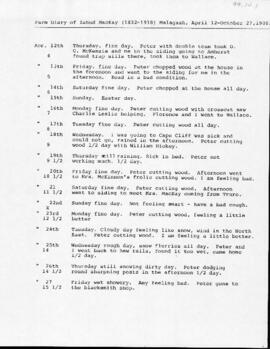
Item is a reproduction of Cape Breton and the Western Harvest Excursions 1890-1928 / A.A. MacKenzie, from "Cape Breton at 200: Historical Essays in Honor of the Island’s Bicentennial 1785 – 1985", pages 71-83. Published by University College of Cape Breton Press, Sydney, N.S. Original dated April 10, 1851, Fredericton, N.B.

Photograph of the Bible Hill School Garden in Bible Hill, Nova Scotia

Item is a photograph of the Bible Hill School Garden in Bible Hill, Nova Scotia. The Bible Hill School was located on College Road in Bible Hill where the woodsman lot is located on the campus of the Dalhousie Agricultural Campus, formerly the Nova Scotia Agricultural College. The photograph is dated August 6, 1914. Initials "K.B.". Men, women and children working in the garden with hand tools, school featured in the background. Notation on the reverse of the photograph "Bible Hill School Garden. Truro NS. Aug 6. 1914."
Results 1151 to 1200 of 294767