File consists of the plans showing the properties that border Lindwood Farms in Sackville, Nova Scotia. These borders include properties owned by Moirs; Hefler Lumber; Wambolt; Hopkins; Hilchie; Davis; Kelsie and Lively.
File consists of one Municipal Development Plan for Sackville zoning, schedule B; two survey plans surveyed by Wallace MacDonald Limited and one Canadian Plant and Process Engineering Limited (CPPE) plan.
Item consists of a plan surveyed by G. G. Grant showing the where the Nova Scotia Power Corporation was to place the transmission line in the Brushy Hill - Lakeside area;
Series contains Jill Grant's records from the Joint Review Panel for the Whites Point Quarry and Marine Terminal Project. Materials include the project's environmental impact statement, transcripts from scoping meetings and public hearings, records of the Joint Review Panel, reference and research materials, correspondence, maps and photographs, and other records. The series provides a comprehensive record of the activities of the Joint Review Panel, which was made up by Jill Grant, Robert Fournier and Gunter Muecke.
Collection contains three historic maps collected by George Burden. The maps depict Cape Breton and Louisbourg, Nova Scotia. Burden acquired the maps from Zwicker's Gallery in Halifax, Nova Scotia.
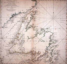
Item is a hand-coloured engraving of Cape Breton extracted from Atlas minimus, or, A new set of pocket maps of the several empires, kingdoms and states of the known world, published in 1758 by John Gibson and Emmanuel Bowen. The map appeared on page 46 of the book.
Series comprises Ronald St. John Macdonald's records regarding his professional activities, including his involvement with different organizations, such as the Council of Europe, the European Court of Human Rights, the Hague, World Academy of Arts and Science, Canadian Council of International Law, United Nations, Institute of International Law, African Society of International Law, British Institute of International Law, Canadian Institute of International Law, International Law Association, and others. Series contains meeting agendas, meeting minutes, newsletters, reports, and other records.
Subseries consists of Ronald St. John Macdonald's records regarding his consultation work for the Republic of Cyprus. Subseries contains a draft constitution for the Federal Republic of Cyprus, bulletins, newspaper clippings, reports, and other materials.
Subseries consists of Ronald St. John Macdonald's records regarding his involvement with the Gulf of Maine case. Subseries contains correspondence, a memorandum of agreement, newspaper clippings, reports, and other materials.
Item is a drawing of the proposed location of the former archives building (now the Chase Building) on Dalhousie University's Studley campus, showing ground elevations.
File comprises unrealized aerial perspective and site plan drawings for a future medical school at Dalhousie. There are also two plans of Studley campus showing the potential site for the new King's College buildings.
Item is map drawn by H.R. Theakston, University Engineer, showing Dalhousie and other associated buildings on and near both Studley Campus and Carleton Campus. The drawing includes a key indicating the names of both existing and proposed buildings. It was originally made on May 14, 1924 and revised on June 30, 1925.
Item is map drawn by H.R. Theakston, University Engineer, showing Dalhousie and other associated buildings on and near both Studley Campus and Carleton Campus. The drawing includes a key indicating the names of both existing and proposed buildings.
File contains proposed building site plans for Studley Campus drawn by H.R. Theakston, university engineer, as well as topographical maps of the Studley Estate prior to Dalhousie construction, including one created by engineering students. There are also several maps dating between 1922-1928 showing the campus's development.
File contains hand-drawn and printed maps of coal fields and designated areas, including Pictou coal fields; the Mining Association area; Cape Breton Company's areas; Albion Mines; Stellar Mine; Fraser Oil-Coal Mines; Intercolonial Coal Mining Company property; East River Mining Company area; Acadian Coal Company areas; and the Halifax Company Ltd.
Item is a map of the Africville Area Land Ownership and Buildings, drawn by P.E.J. on July 26, 1962, for the Halifax City Planning Office, at a scale of 1" = 100'. Verso map also contains an inked list of property numbers, some crossed out and others checked off.
Item is a map showing the locations of the mill construction; ruins of the old brick kilns; the clay shed; the new brick kilns; pipe drying; power house and machinery department near the Park Road address.
Item is a map of the harbour of present-day Halifax, Nova Scotia created in 1779 by Joseph-Bernard de Chabert. The map was commissioned by Antoine de Sartine. Depths shown by soundings.
Item is a chart of the Magdalen Islands created by Thomas Jefferys. The chart was published in A Collection of Charts of the coasts of Newfoundland and Labrador (London 1765-1768). Item is entry 604 in Kershaw's Early printed maps of Canada.
Item is a map of British America drawn and engraved by J. Rapkin. Illustrations on the map were drawn by H. Warren and engraved by Robert Wallis. The map was published in J. & F. Tallis' Illustrated atlas, and modern history of the World in 1851.
Item is a map of West Canada drawn and engraved by J. Rapkin. Illustrations on the map were drawn by H. Warren and engraved by Robert Wallis. The map was published in J. & F. Tallis' Illustrated atlas, and modern history of the World in 1851.
Item is a map of East Canada and New Brunswick drawn and engraved by J. Rapkin. Illustrations on the map were drawn by H. Warren and engraved by Robert Wallis. The map was published in J. & F. Tallis' Illustrated atlas, and modern history of the World in 1851.
Fonds consists of materials collected by Ronald Justin Inness about ships and shipping companies, including pamphlets, manuscripts, clippings, and correspondence. Fonds also contains manuscripts written by Ronald Justin Inness about the Innes' genealogy.
Item consists of an unattributed hand-drawn, colour map of the Dalhousie University campus, drawn in December 1962, titled "Ground Plan of Dalhousie University".
Item consists of a hand-drawn, colour map of proposed changes to zoning of the Dalhousie University campus, dated December 2, 1965 and drawn by J. Edmonds. Includes proposals of rezoning several blocks from R-3 zone to Park and Institutional zone.
File contains a set of presentation drawings on board created by Drew Sperry as his Bachelor of Architecture terminal design project at the Nova Scotia Technical College. Drawings include an urban context map; site plan; mechanical plan, floor plans; elevations; section perspective; and street views.
Fonds contains architectural drawings created by Drew Sperry as a student at Nova Scotia Technical College and later as a certified architect. His student work comprises presentation drawings, while the designs for his own home in Dartmouth, Nova Scotia, and two other residential commissions include both presentation and construction drawings. There are two folders of textual records, which comprise a transcript of an interview with Drew and Sheila Sperry, real estate appraisals of their Dartmouth residence, and early budget breakdowns from Sperry's architectural practice.
Item is a presentation drawing created by Drew Sperry of the urban context of a proposed YMCA for Halifax, which was Sperry's terminal design project for his Bachelor of Architecture degree at the Nova Scotia Technical College. His plan for the recreational complex is superimposed on to a map of Halifax.
Fonds comprises Ronald St. John Macdonald's records regarding his personal, academic, and professional activities as a jurist, judge, and professor. Records include those related to Macdonald's involvement with Osgoode Hall, University of Western Ontario, University of Toronto, Dalhousie University, the European Court of Human Rights, the Hague, Peking University, World Academy of Arts and Science, Canadian Council of International Law, United Nations, Institute of International Law, African Society of International Law, British Institute of International Law, Canadian Institute of International Law, International Law Association, and others. Records types include correspondence; meeting minutes and agendas; research materials; photographs; newsletters; newspaper clippings; manuscripts; and off-prints.


![Ground plan of Dalhousie University : [map]](/uploads/r/dalhousie-university-archives/0/a/8/0a834f8be003875dbec4cda568fa7e0a24fae39ff5f4cfbb41c3d54d5495bd16/83655f0e-ef17-4831-90a0-73b6ffee38ca-UA-3_487_3_8_142.jpg)
![Proposed rezoning of lands as requested by Dalhousie College and University : [map]](/uploads/r/dalhousie-university-archives/8/6/1/861e617d5c96adf38c584d108c62d54870ae9f68c9c916a83c380a66ad409665/55aba0d1-efab-43d7-bbbd-aef7f5557f2a-UA-3_487_3_9_142.jpg)
