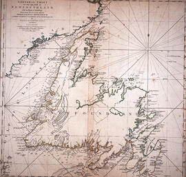
Item is a chart of the Magdalen Islands created by Thomas Jefferys. The chart was published in A Collection of Charts of the coasts of Newfoundland and Labrador (London 1765-1768). Item is entry 604 in Kershaw's Early printed maps of Canada.
Item is a map of British America drawn and engraved by J. Rapkin. Illustrations on the map were drawn by H. Warren and engraved by Robert Wallis. The map was published in J. & F. Tallis' Illustrated atlas, and modern history of the World in 1851.
Item is a map of West Canada drawn and engraved by J. Rapkin. Illustrations on the map were drawn by H. Warren and engraved by Robert Wallis. The map was published in J. & F. Tallis' Illustrated atlas, and modern history of the World in 1851.
Item is a map of East Canada and New Brunswick drawn and engraved by J. Rapkin. Illustrations on the map were drawn by H. Warren and engraved by Robert Wallis. The map was published in J. & F. Tallis' Illustrated atlas, and modern history of the World in 1851.
File consists of seven black and white maps of the Jos Plateau. The maps display national boundaries, migration routes, settlements, ethnic groups, pathways of British expeditions and main roads.
Fonds consists of materials collected by Ronald Justin Inness about ships and shipping companies, including pamphlets, manuscripts, clippings, and correspondence. Fonds also contains manuscripts written by Ronald Justin Inness about the Innes' genealogy.
File consists of eighteen black and white, and colour maps of the Jos Plateau. The file includes five transparent copies of maps of the Jos Plateau used in James Morrison's thesis. The remaining thirteen maps are a combination of government and topographical maps of the Jos Plateau region of Nigeria.
File is comprised of documents related to data sampling in the city of Abeokuta. Contains lists of names, notes on divisions of neighbourhoods, and information and statistics relating to city areas and squares. Also contains a large folded map of Abeokuta.
Subseries contains files of information for each village in the study. Includes social and historical research notes and population medical survey results. Also contains hand-drawn maps and lists of respondents' names.
File contains social and historical research notes and population medical survey results for the village of Apena. File includes two hand-drawn maps of the village. Researchers considered the village traditional.
File contains social and historical research notes and population medical survey results for the village of Ilewo. File includes two hand-drawn maps of the village. Researchers considered the village modern.
File contains social and historical research notes and population medical survey results for the village of Agada. File includes three hand-drawn maps of the village. Researchers considered the village traditional.
File contains social and historical research notes and population medical survey results for the village of Ilewo. File includes one hand-drawn map of the village. Researchers considered the village traditional.
File contains social and historical research notes and population medical survey results for the village of Ashipa. File includes three hand-drawn maps of the village. Researchers considered the village modern.
File contains social and historical research notes and population medical survey results for the village of Shodeke. File includes two hand-drawn maps of the village. Researchers considered the village modern.
File contains social and historical research notes and population medical survey results for the village of Joko. File includes two hand-drawn maps of the village. Researchers considered the village traditional.
File contains social and historical research notes and population medical survey results for the village of Ikereku. File includes three hand-drawn maps of the village. Researchers considered the village modern.
File contains social and historical research notes and population medical survey results for the village of Ijeun-Lukosi. File includes two hand-drawn maps of the village. Researchers considered the village modern.
File contains social and historical research notes and population medical survey results for the village of Akaa. File includes three hand-drawn maps of the village. Researchers considered the village traditional.
File contains social and historical research notes and population medical survey results for the village of Kutaw. File includes two hand-drawn maps of the village. Researchers considered the village modern.
File contains social and historical research notes and population medical survey results for the village of Ijeja Kenta. File includes two hand-drawn maps of the village. Researchers considered the village traditional.
File contains social and historical research notes and population medical survey results for the village of Awaro. File includes two hand-drawn maps of the village. Researchers considered the village modern.
File contains social and historical research notes, field notes, and population medical survey results for the village of Opeji. File includes four hand-drawn maps of the village.
File contains social and historical research notes and population medical survey results for the village of Adekanbi. File includes one hand-drawn map.
File contains social and historical research notes and population medical survey results for the village of Idi-Ori. File includes two hand-drawn maps of the village.
File contains social and historical research notes and population medical survey results for several villages. File includes two hand-drawn maps and several lists of names.
File contains keepsakes from Alexander Leighton's trip to Japan, including photographs, postcards, maps, medical documents and immunization records, and travel itineraries.
Item consists of an unattributed hand-drawn, colour map of the Dalhousie University campus, drawn in December 1962, titled "Ground Plan of Dalhousie University".
Item consists of a hand-drawn, colour map of proposed changes to zoning of the Dalhousie University campus, dated December 2, 1965 and drawn by J. Edmonds. Includes proposals of rezoning several blocks from R-3 zone to Park and Institutional zone.
File contains a set of presentation drawings on board created by Drew Sperry as his Bachelor of Architecture terminal design project at the Nova Scotia Technical College. Drawings include an urban context map; site plan; mechanical plan, floor plans; elevations; section perspective; and street views.
Fonds contains architectural drawings created by Drew Sperry as a student at Nova Scotia Technical College and later as a certified architect. His student work comprises presentation drawings, while the designs for his own home in Dartmouth, Nova Scotia, and two other residential commissions include both presentation and construction drawings. There are two folders of textual records, which comprise a transcript of an interview with Drew and Sheila Sperry, real estate appraisals of their Dartmouth residence, and early budget breakdowns from Sperry's architectural practice.
Item is a presentation drawing created by Drew Sperry of the urban context of a proposed YMCA for Halifax, which was Sperry's terminal design project for his Bachelor of Architecture degree at the Nova Scotia Technical College. His plan for the recreational complex is superimposed on to a map of Halifax.
File consists of a notebook of drawings created by James H. Morrison, and three maps of the Jos Plateau in Nigeria. One map was created in 1903 and is a visualization of the settlements on the Jos Plateau; one map is a visualization of Nigeria with a focus on Jos Plateau; one map is entitled "The Fulani Jihad and those Settlements on the Jos Plateau Affected by the Emirates and/or their Allies" and displays the attack strategy of Jemaa, Zaria, Ningi, and Bauchi groups. The notebook contains colour pencil crayon drawings of styles of dress in Assakio Village with descriptive titles.


![Ground plan of Dalhousie University : [map]](/uploads/r/dalhousie-university-archives/0/a/8/0a834f8be003875dbec4cda568fa7e0a24fae39ff5f4cfbb41c3d54d5495bd16/83655f0e-ef17-4831-90a0-73b6ffee38ca-UA-3_487_3_8_142.jpg)
![Proposed rezoning of lands as requested by Dalhousie College and University : [map]](/uploads/r/dalhousie-university-archives/8/6/1/861e617d5c96adf38c584d108c62d54870ae9f68c9c916a83c380a66ad409665/55aba0d1-efab-43d7-bbbd-aef7f5557f2a-UA-3_487_3_9_142.jpg)