Hand-drawn map of Granville Street, Port Hawkesbury
- MS-2-838, Box 3, Folder 8
- Item
- 1989
Part of Christopher Heide fonds
Item is a hand-drawn map of Granville Street, Port Hawkesbury, indicating the names and locations of historical businesses.
2 results directly related Exclude narrower terms
Hand-drawn map of Granville Street, Port Hawkesbury
Part of Christopher Heide fonds
Ronald St. John Macdonald fonds
Macdonald, Ronald St. John, 1928-2006

Part of Drew Sperry fonds
Sperry, Henry Drew
Part of Drew Sperry fonds
![Ground plan of Dalhousie University : [map]](/uploads/r/dalhousie-university-archives/0/a/8/0a834f8be003875dbec4cda568fa7e0a24fae39ff5f4cfbb41c3d54d5495bd16/83655f0e-ef17-4831-90a0-73b6ffee38ca-UA-3_487_3_8_142.jpg)
Ground plan of Dalhousie University : [map]
Part of President’s Office fonds
![Proposed rezoning of lands as requested by Dalhousie College and University : [map]](/uploads/r/dalhousie-university-archives/8/6/1/861e617d5c96adf38c584d108c62d54870ae9f68c9c916a83c380a66ad409665/55aba0d1-efab-43d7-bbbd-aef7f5557f2a-UA-3_487_3_9_142.jpg)
Proposed rezoning of lands as requested by Dalhousie College and University : [map]
Part of President’s Office fonds
Part of Ronald Justin Inness fonds
Inness, Ronald Justin
Part of R. Graham Murray fonds
Map of Nova Scotia or Acadia with the islands of Cape Breton and Saint John
Part of The Pullen Map Collection
Map of East Canada and New Brunswick
Part of The Pullen Map Collection
Part of The Pullen Map Collection

Chart of the Magdalen Islands in the Gulf of St. Lawrence, surveyed in 1765
Part of The Pullen Map Collection

Chart of the harbour of Halifax in Nova Scotia
Part of The Pullen Map Collection
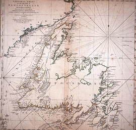
Chart of the Island of Newfoundland
Part of The Pullen Map Collection

Part of The Pullen Map Collection
Bellin, Jacques Nicolas, 1703-1772

Plan of the city and Harbour of Louisbourg
Part of The Pullen Map Collection

Karte von dem Ostlichen-Stucke von Neu Frankreich oder Canada
Part of The Pullen Map Collection
Bellin, Jacques Nicolas, 1703-1772

Plan du port de Chibouctou à la côte de l'Acadie avec les côtes voisines
Part of The Pullen Map Collection
Exact chart of the River Saint Lawrence
Part of The Pullen Map Collection
Part of Standard Clay Products Limited

Part of John and Robert Rutherford fonds
Site plans and maps of Studley campus
Part of Facilities Management

Dalhousie University grounds and buildings : erected and proposed
Part of Facilities Management

Dalhousie University grounds and buildings : erected and proposed
Part of Facilities Management

Proposed location for the Archives building on Studley campus
Part of Facilities Management
Potential medical school site plans and and aerial perspective drawings
Part of Facilities Management
Maps related to the Gulf of Maine case
Part of Ronald St. John Macdonald fonds
Part of Ronald St. John Macdonald fonds
Part of Ronald St. John Macdonald fonds
Ronald St. John Macdonald’s professional records
Part of Ronald St. John Macdonald fonds
Dalhousie University campus maps
Part of Dalhousie University Class of 1931 - century package collection
Map of the lots on Atlantic-Acadia-Brussels streets belonging to J.E. Roy, 1911
Part of Hector McInnes fonds
Part of George Burden map collection
Bowen, Emmanuel, 1694-1767
Port de Louisebourg dans l'Isle Royale
Part of George Burden map collection
Bellin, Jacques Nicolas, 1703-1772
Part of George Burden map collection
Randle, Charles, 1755-1813

Map of Musquodoboit Harbour Rural Telephone Company lines

Map of Petpeswick Harbour Mutual Telephone Company's telephone line
Records from the Joint Review Panel for the Whites Point Quarry and Marine Terminal Project
Part of Jill Grant fonds
Part of Oland and Son fonds
Plan showing Lot D1 of the Carl Hamilton property for transfer to Lindwood Farms
Part of Oland and Son fonds
Plan of survey for properties of Olands at Northfield, Hants County, Nova Scotia
Part of Oland and Son fonds
Part of Oland and Son fonds
Part of Oland and Son fonds
Plans showing the property borders surrounding Lindwood Farms, Sackville, Nova Scotia
Part of Oland and Son fonds
Oland Estate : Plan of lands at Sackville, Nova Scotia, property of George W. C. Oland
Part of Oland and Son fonds
Part of Oland and Son fonds