- MS-4-135.2019-046, OS Folder 47
- File
- 1962 - 1963
Part of Oland and Son fonds
This file consists of a map of the Lindwood Farms and the surrounding area.
33 results with digital objects Show results with digital objects
Part of Oland and Son fonds
Part of Oland and Son fonds
Correspondence between Fred and Eloise Jarrett and Henry Davies Hicks
Part of Henry Davies Hicks fonds
Maps of fish farming in the Faroes for 1984, 1990, 1995 and 1999
Part of Richard Apostle fonds
Campus map of the Nova Scotia Technical College
Plan of survey of lands of Lindwood Holdings Limited in Seabright, Halifax County, Nova Scotia
Part of Oland and Son fonds
Part of Oland and Son fonds
Plan of survey of lands of Richard H. Oland, Tremont Street, Chester, Lunenburg County, Nova Scotia
Part of Oland and Son fonds
Part of Oland and Son fonds
Plan of survey of Block - WK - Bluenose Wharf, property of A. Keith & Son Limited
Part of Oland and Son fonds
Part of Oland and Son fonds
Oland Estate : Plan of lands at Sackville, Nova Scotia, property of George W. C. Oland
Part of Oland and Son fonds
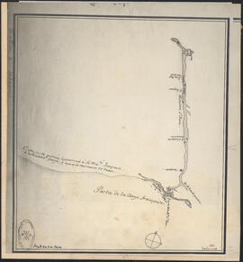
Plans showing the property borders surrounding Lindwood Farms, Sackville, Nova Scotia
Part of Oland and Son fonds
Part of Oland and Son fonds
Part of Oland and Son fonds
Plan of survey for properties of Olands at Northfield, Hants County, Nova Scotia
Part of Oland and Son fonds
Plan showing Lot D1 of the Carl Hamilton property for transfer to Lindwood Farms
Part of Oland and Son fonds
Part of Oland and Son fonds
Material related to the construction of Bruce Oland's property on the Northwest Arm : The Anchor
Part of Oland family fonds
Records from the Joint Review Panel for the Whites Point Quarry and Marine Terminal Project
Part of Jill Grant fonds

Map of Petpeswick Harbour Mutual Telephone Company's telephone line

Map of Musquodoboit Harbour Rural Telephone Company lines
Part of George Burden map collection
Randle, Charles, 1755-1813
Port de Louisebourg dans l'Isle Royale
Part of George Burden map collection
Bellin, Jacques Nicolas, 1703-1772
Part of George Burden map collection
Bowen, Emmanuel, 1694-1767
Map of the lots on Atlantic-Acadia-Brussels streets belonging to J.E. Roy, 1911
Part of Hector McInnes fonds
Dalhousie University campus maps
Part of Dalhousie University Class of 1931 - century package collection
Ronald St. John Macdonald’s professional records
Part of Ronald St. John Macdonald fonds
Part of Ronald St. John Macdonald fonds
Research materials regarding the revision of the Republic of Cyprus constitution
Part of Ronald St. John Macdonald fonds
Maps related to the Gulf of Maine case
Part of Ronald St. John Macdonald fonds
Part of Ronald St. John Macdonald fonds

Proposed location for the Archives building on Studley campus
Part of Facilities Management
Potential medical school site plans and and aerial perspective drawings
Part of Facilities Management

Dalhousie University grounds and buildings : erected and proposed
Part of Facilities Management

Dalhousie University grounds and buildings : erected and proposed
Part of Facilities Management
Site plans and maps of Studley campus
Part of Facilities Management
Part of John and Robert Rutherford fonds

Plans and maps of the Hawker Siddley - Trenton Works Division plant in Trenton, Nova Scotia
Part of Trenton Works Ltd. Fonds
Part of Standard Clay Products Limited
Research material related to World War I
Part of Archibald MacMechan fonds
Exact chart of the River Saint Lawrence
Part of The Pullen Map Collection

Plan du port de Chibouctou à la côte de l'Acadie avec les côtes voisines
Part of The Pullen Map Collection
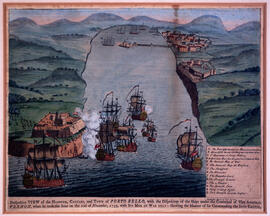
Perspective view of the harbour, coasts and town of Porto Bello
Part of The Pullen Map Collection

Karte von dem Ostlichen-Stucke von Neu Frankreich oder Canada
Part of The Pullen Map Collection
Bellin, Jacques Nicolas, 1703-1772

Plan of the city and Harbour of Louisbourg
Part of The Pullen Map Collection

Part of The Pullen Map Collection
Bellin, Jacques Nicolas, 1703-1772