Plan of survey of lands of Richard H. Oland, Tremont Street, Chester, Lunenburg County, Nova Scotia
Plan of survey of lands of Richard H. Oland, Tremont Street, Chester, Lunenburg County, Nova Scotia
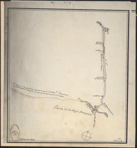
Hand-drawn map of Granville Street, Port Hawkesbury
Hand-drawn map of Granville Street, Port Hawkesbury
Nova Scotia Power Corporation plan of lots 16 - 17b, Brushy Hill - Lakeside, placement of the transmission line
Nova Scotia Power Corporation plan of lots 16 - 17b, Brushy Hill - Lakeside, placement of the transmission line
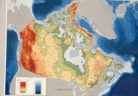
Transparency relief map of Canada
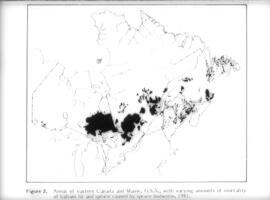
Transparency map showing areas of spruce budworm infestation in eastern Canada, 1981
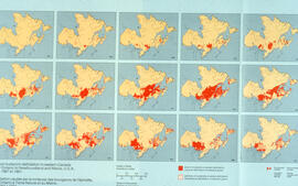
Collage of maps showing the spread of spruce budworm in eastern Canada, 1967-1981

Transparency map of continental shelf off Nova Scotia and Sable Island

Transparency relief map of Sable Island

Transparency relief map of Sable Island

Urban context
![Proposed rezoning of lands as requested by Dalhousie College and University : [map]](/uploads/r/dalhousie-university-archives/8/6/1/861e617d5c96adf38c584d108c62d54870ae9f68c9c916a83c380a66ad409665/55aba0d1-efab-43d7-bbbd-aef7f5557f2a-UA-3_487_3_9_142.jpg)
Proposed rezoning of lands as requested by Dalhousie College and University : [map]
Plan of survey showing property of S. C. Oland, Pleasant Street - Central Street, Chester, Lunenburg County, Nova Scotia
Plan of survey showing property of S. C. Oland, Pleasant Street - Central Street, Chester, Lunenburg County, Nova Scotia
![Ground plan of Dalhousie University : [map]](/uploads/r/dalhousie-university-archives/0/a/8/0a834f8be003875dbec4cda568fa7e0a24fae39ff5f4cfbb41c3d54d5495bd16/83655f0e-ef17-4831-90a0-73b6ffee38ca-UA-3_487_3_8_142.jpg)
Ground plan of Dalhousie University : [map]

Map of Africville

Map of Musquodoboit Harbour Rural Telephone Company lines

Plan showing properties bounded by Bishop, Hollis, Salter & Water Streets

Map of Petpeswick Harbour Mutual Telephone Company's telephone line
The map "Coast of Acadie" by Lalanne, 1684, used by William Inglis Morse in volume II of Acadiensia Nova in 1935
Oland Estate : Plan of lands at Sackville, Nova Scotia, property of George W. C. Oland
Oland Estate : Plan of lands at Sackville, Nova Scotia, property of George W. C. Oland
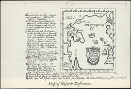
Illustration on page 29 of the first edition of the Markland Sagas : Map of Sigurd Stefansson
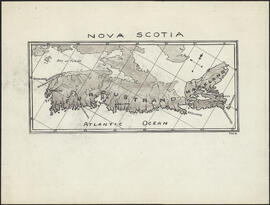
Illustration on page 30 of the first edition of The Markland Sagas : Map of Nova Scotia with Norse Placenames
Map of the Standard Clay Products Ltd, New Glasgow, Nova Scotia and D LeBlanc & Fils Limitee property / by J. Saur
Map of the Standard Clay Products Ltd, New Glasgow, Nova Scotia and D LeBlanc & Fils Limitee property / by J. Saur

Proposed location for the Archives building on Studley campus

Dalhousie University grounds and buildings : erected and proposed

Dalhousie University grounds and buildings : erected and proposed
Map of West Canada
Map of West Canada
Map of East Canada and New Brunswick
Map of East Canada and New Brunswick
Map of British America
Map of British America
Property plan for Canning

Chart of the Magdalen Islands in the Gulf of St. Lawrence, surveyed in 1765
Map of Cape Breton
Map of Cape Breton

Plan du port de Chibouctou à la côte de l'Acadie avec les côtes voisines
New map of Nova Scotia and Cape Breton Island
New map of Nova Scotia and Cape Breton Island
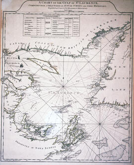
Chart of the Gulf of Saint Lawrence
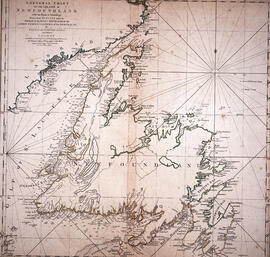
Chart of the Island of Newfoundland

Chart of the harbour of Halifax in Nova Scotia
Exact chart of the River Saint Lawrence
Exact chart of the River Saint Lawrence
Map of Nova Scotia or Acadia with the islands of Cape Breton and Saint John
Map of Nova Scotia or Acadia with the islands of Cape Breton and Saint John
Port de Louisebourg dans l'Isle Royale
Port de Louisebourg dans l'Isle Royale

Plan de la Baye de Chibouctou
Island of Cape Breton
Island of Cape Breton

Plan of the city and Harbour of Louisbourg

Karte von dem Ostlichen-Stucke von Neu Frankreich oder Canada
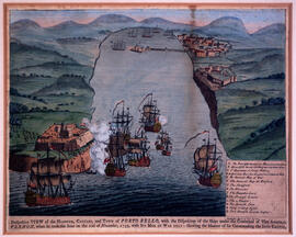
Perspective view of the harbour, coasts and town of Porto Bello